Pāriet uz saturu

Attēls:New Smethwick Pumping Station 2.jpg

Lapas saturs netiek atbalstīts citās valodās.
Vikipēdijas lapa

Sākotnējais fails (2 592 × 1 944 pikseļi, faila izmērs: 1,7 MB, MIME tips: image/jpeg)

Apraksts
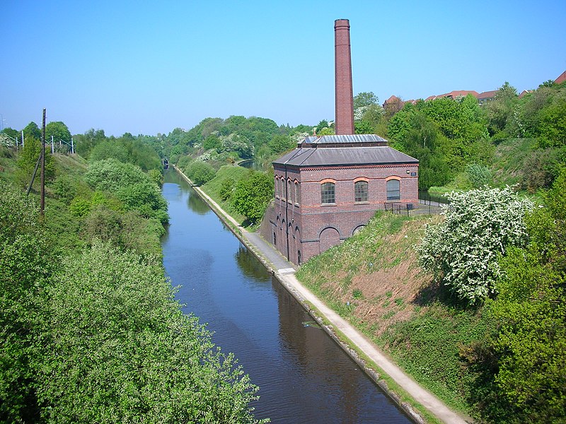
English: Smethwick New Pumping Station, Brasshouse Lane, Smethwick, West Midlands. The building is between the old and new lines of the BCN Main Line near Brasshouse Lane bridge, Smethwick, West Midlands, England. The engine pumped water from the lower canal (Birmingham Level) to the upper (Wolverhampton Level) in order to supply the locks at the Smethwick Summit of the older canal, replacing the original pumping engine on the corner of Rolfe Street and Bridge Street. Photographed by me 2 May 2007. Oosoom
Datums 2007. gada 3. jūnijs (original upload date)
Avots Transferred from en.wikipedia to Commons.
Autors Oosoom at angļu Vikipēdija
Atļauja:
(Šī faila izmantošana citur)
Oosoom at angļu Vikipēdija, šī darba autortiesību īpašnieks, publicē to saskaņā ar šīm licencēm:
GNU head Ir dota atļauja kopēt, izplatīt un/vai pārveidot šo dokumentu saskaņā ar GNU brīvās dokumentācijas licences, versijas 1.2 vai jebkuras vēlākas versijas, ko publiskojis Brīvās programmatūras fonds nosacījumiem; bez nemainīgajām sadaļā, priekšējā un aizmugurēja'vāka tekstiem. Licences kopija ir iekļauta sadaļā ar nosaukumu GNU brīvās dokumentācijas licence.
w:en:Creative Commons
atsaucoties nemainot licenci
Šis fails tiek izplatīts saskaņā ar licences Creative Commons Atsauce-Līdzīgi Noteikumi 3.0 Vispārējiem noteikumiem.
Jūs varat brīvi:
  • koplietot – kopēt, izplatīt un pārraidīt darbu
  • remiksēt – pielāgot darbu
Saskaņā ar šādiem nosacījumiem:
  • atsaucoties – Tev ir jānorāda autors, saite uz licenci un to, vai veiktas kādas izmaiņas. To var darīt jebkādā saprātīgā veidā, bet ne tādā, kas norādītu, ka licencētājs atbalsta tevi vai veidu, kā tu izmanto šo darbu.
  • nemainot licenci – Ja tu miksē, pārveido vai izmanto materiālu, tev savs devums jāpublicē ar to pašu vai saderīgu licenci kā oriģināls.
Jūs varat izvēlēties licenci pēc jūsu vēlmes.
Camera location52° 29′ 53,16″ N, 1° 58′ 23,16″ W Kartographer map based on OpenStreetMap.View this and other nearby images on: OpenStreetMapinfo

Original upload log

The original description page was here. All following user names refer to en.wikipedia.
  • 2007-06-03 20:41 Oosoom 2592×1944×8 (1780796 bytes) New Smethwick Pumping Station {{IoEgrade|219213|II}}, between the old and new lines of the [[Birmingham Canal Navigations]] near Brasshouse Lane bridge, [[Smethwick]], [[West Midlands (county)|West Midlands]], England. The engine pumped water from the low

Captions

Pievieno vienas rindiņas aprakstu, ko šis fails attēlo

Šajā failā attēlotais

attēlo

52°29'53.2"N, 1°58'23.2"W

ISO speed angļu

50

0,017857142857143 sekunde

f-number angļu

8,5

5,8 milimetrs

Faila hronoloģija

Uzklikšķini uz datums/laiks kolonnā esošās saites, lai apskatītos, kā šis fails izskatījās tad.

Datums/LaiksAttēlsIzmēriDalībnieksKomentārs
tagadējais2008. gada 20. februāris, plkst. 12.402008. gada 20. februāris, plkst. 12.40 versijas sīktēls2 592 × 1 944 (1,7 MB)Oosoom{{Information |Description={{en|New Smethwick Pumping Station , between the old and new lines of the en:BCN Main Line near Brasshouse Lane bridge, en:Smethwick, West Midlands, England. The engine pumped water from

Šo failu izmanto šajā 1 lapā:

Globālais faila lietojums

Šīs Vikipēdijas izmanto šo failu:

Metadati