
Attēls:New guinea named.PNG

Šī priekšskata izmērs: 800 × 417 pikseļi. Citi izmēri: 320 × 167 pikseļi | 640 × 333 pikseļi | 1 024 × 534 pikseļi | 1 280 × 667 pikseļi | 2 205 × 1 149 pikseļi.
Sākotnējais fails (2 205 × 1 149 pikseļi, faila izmērs: 86 KB, MIME tips: image/png)
| Šis fails ir no Vikikrātuves. Tā apraksts no attēla lapas Vikikrātuvē ir parādīts zemāk. Vikikrātuve ir brīvi licencēta failu krātuve. Tu vari tai palīdzēt. |

|
This locator map image could be re-created using vector graphics as an SVG file. This has several advantages; see Commons:Media for cleanup for more information. If an SVG form of this image is available, please upload it and afterwards replace this template with
{{vector version available|new image name}}.
It is recommended to name the SVG file “New guinea named.svg”—then the template Vector version available (or Vva) does not need the new image name parameter. |
Kopsavilkums
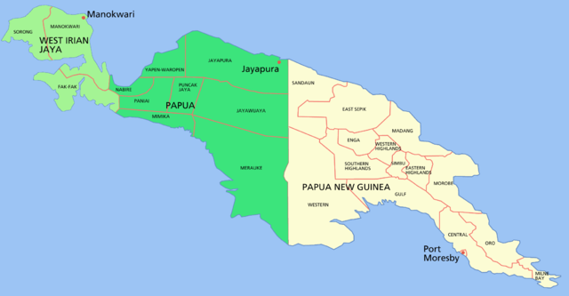
Map of the island of w:New Guinea
- Green = western New Guinea, (Indonesia) divided into the two provinces of West Irian Jaya (light green) and Papua (dark green).
- Beige = eastern New Guinea, the 'mainland' portion of the nation of Papua New Guinea
Shows capital cities and provinces
For a blank map see Image:New guinea blank.PNG
Licence

|
Ir dota atļauja kopēt, izplatīt un/vai pārveidot šo dokumentu saskaņā ar GNU brīvās dokumentācijas licences, versijas 1.2 vai jebkuras vēlākas versijas, ko publiskojis Brīvās programmatūras fonds nosacījumiem; bez nemainīgajām sadaļā, priekšējā un aizmugurēja'vāka tekstiem. Licences kopija ir iekļauta sadaļā ar nosaukumu GNU brīvās dokumentācijas licence. |
| Šis fails tiek izplatīts saskaņā ar licences Creative Commons Atsauce-Līdzīgi Noteikumi 3.0 Vispārējiem noteikumiem. | ||
| ||
| This licensing tag was added to this file as part of the GFDL licensing update. |
Faila hronoloģija
Uzklikšķini uz datums/laiks kolonnā esošās saites, lai apskatītos, kā šis fails izskatījās tad.
| Datums/Laiks | Attēls | Izmēri | Dalībnieks | Komentārs | |
|---|---|---|---|---|---|
| tagadējais | 2006. gada 24. februāris, plkst. 07.29 | | 2 205 × 1 149 (86 KB) | Roke~commonswiki | Map of the island of New Guinea Category: New Guinea |
Faila lietojums
Šo failu izmanto šajā 1 lapā:
Globālais faila lietojums
Šīs Vikipēdijas izmanto šo failu:
- Izmantojums af.wikipedia.org
- Izmantojums als.wikipedia.org
- Izmantojums ar.wikipedia.org
- Izmantojums ban.wikipedia.org
- Izmantojums bat-smg.wikipedia.org
- Izmantojums ca.wikipedia.org
- Izmantojums cs.wikipedia.org
- Izmantojums de.wikipedia.org
- Izmantojums de.wikinews.org
- Izmantojums el.wikipedia.org
- Izmantojums en.wikipedia.org
- Izmantojums en.wiktionary.org
- Izmantojums es.wikipedia.org
- Izmantojums fa.wikipedia.org
- Izmantojums fi.wikipedia.org
- Izmantojums fr.wikipedia.org
- Izmantojums gd.wikipedia.org
- Izmantojums gl.wikipedia.org
- Izmantojums gn.wikipedia.org
- Izmantojums hak.wikipedia.org
- Izmantojums he.wikipedia.org
- Izmantojums hu.wikipedia.org
- Izmantojums id.wikipedia.org
- Izmantojums id.wiktionary.org
- Izmantojums ja.wikipedia.org
- Izmantojums ka.wikipedia.org
Skatīt šī faila pilno globālo izmantojumu.