
Attēls:Saint-Barthélemy collectivity relief location map.jpg

Šī priekšskata izmērs: 800 × 526 pikseļi. Citi izmēri: 320 × 210 pikseļi | 640 × 420 pikseļi | 1 024 × 673 pikseļi | 1 175 × 772 pikseļi.
Sākotnējais fails (1 175 × 772 pikseļi, faila izmērs: 172 KB, MIME tips: image/jpeg)
| Šis fails ir no Vikikrātuves. Tā apraksts no attēla lapas Vikikrātuvē ir parādīts zemāk. Vikikrātuve ir brīvi licencēta failu krātuve. Tu vari tai palīdzēt. |
Kopsavilkums
| Camera location | | View this and other nearby images on: OpenStreetMap |
|---|
| Apraksts |
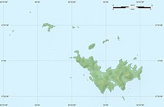
English: Blank physical map of the overseas collectivity of Saint Barthélemy, France, for geo-location purpose.
Français : Carte physique vierge de la collectivité d'outre-mer de Saint-Barthélemy, France, destinée à la géolocalisation. Scales: 1:372,000 (precision: 93 m) for the topography; 1:4,720,000 (precision: 1,180 m) for the bathymetry
Geographic limits of the map:
|
||
| Datums | |||
| Avots |
Paša darbs
|
||
| Autors | Eric Gaba (Sting - fr:Sting) | ||
| Atļauja: (Šī faila izmantošana citur) |
|
||
| Citas versijas |
|


Licence
Eric Gaba, Wikimedia Commons user Sting, šī darba autortiesību īpašnieks, publicē to saskaņā ar šīm licencēm:
Šis fails tiek izplatīts saskaņā ar licences Creative Commons Atsauce-Līdzīgi Noteikumi 3.0 Vispārējiem noteikumiem.
Atsauce: Eric Gaba, Wikimedia Commons user Sting
- Jūs varat brīvi:
- koplietot – kopēt, izplatīt un pārraidīt darbu
- remiksēt – pielāgot darbu
- Saskaņā ar šādiem nosacījumiem:
- atsaucoties – Tev ir jānorāda autors, saite uz licenci un to, vai veiktas kādas izmaiņas. To var darīt jebkādā saprātīgā veidā, bet ne tādā, kas norādītu, ka licencētājs atbalsta tevi vai veidu, kā tu izmanto šo darbu.
- nemainot licenci – Ja tu miksē, pārveido vai izmanto materiālu, tev savs devums jāpublicē ar to pašu vai saderīgu licenci kā oriģināls.

|
Ir dota atļauja kopēt, izplatīt un/vai pārveidot šo dokumentu saskaņā ar GNU brīvās dokumentācijas licences, versijas 1.2 vai jebkuras vēlākas versijas, ko publiskojis Brīvās programmatūras fonds nosacījumiem; bez nemainīgajām sadaļā, priekšējā un aizmugurēja'vāka tekstiem. Licences kopija ir iekļauta sadaļā ar nosaukumu GNU brīvās dokumentācijas licence. |
Jūs varat izvēlēties licenci pēc jūsu vēlmes.
Faila hronoloģija
Uzklikšķini uz datums/laiks kolonnā esošās saites, lai apskatītos, kā šis fails izskatījās tad.
| Datums/Laiks | Attēls | Izmēri | Dalībnieks | Komentārs | |
|---|---|---|---|---|---|
| tagadējais | 2010. gada 19. jūlijs, plkst. 00.14 | | 1 175 × 772 (172 KB) | Sting | Color profile |
| 2010. gada 26. februāris, plkst. 04.39 |  | 1 175 × 772 (167 KB) | Sting | == {{int:filedesc}} == {{Location|17|55|30|N|62|51|45|W|scale:50000}} <br/> {{Information |Description={{en|Blank physical map of the overseas collectivity of Saint Barthélemy, France |
Faila lietojums
Šo failu izmanto šajā 1 lapā:
Globālais faila lietojums
Šīs Vikipēdijas izmanto šo failu:
- Izmantojums ar.wikipedia.org
- Izmantojums ast.wikipedia.org
- Izmantojums bg.wikipedia.org
- Izmantojums bs.wikipedia.org
- Izmantojums ceb.wikipedia.org
- Izmantojums ckb.wikipedia.org
- Izmantojums da.wikipedia.org
- Izmantojums de.wikipedia.org
- Izmantojums en.wikipedia.org
- Izmantojums eo.wikipedia.org
- Izmantojums es.wikipedia.org
- Izmantojums fa.wikipedia.org
- Izmantojums fr.wikipedia.org
- Discussion utilisateur:Pethrus
- Gustavia (Saint-Barthélemy)
- Projet:Cartographie/Cartes standards/France
- Modèle:Géolocdual/Saint-Barthélemy
- Modèle:Géolocalisation/Saint-Barthélemy
- Wikipédia:Atelier graphique/Cartes/Archives/avril 2010
- Morne de Vitet
- Réserve naturelle nationale de Saint-Barthélemy Nicole-Aussedat
- Île Fourchue
- Île Chevreau
- Île Frégate (France)
- Île le Boulanger
- Île Coco
- Pain de Sucre (Saint-Barthélemy)
- Île Pelé
- Île Petit Jean
- Île Toc Vers
- La Tortue (Saint-Barthélemy)
- Liste des mammifères à Saint-Barthélemy
- Izmantojums he.wikipedia.org
- Izmantojums hr.wikipedia.org
Skatīt šī faila pilno globālo izmantojumu.