
Attēls:Shipping routes red black.png

Šī priekšskata izmērs: 800 × 400 pikseļi. Citi izmēri: 320 × 160 pikseļi | 640 × 320 pikseļi | 1 024 × 512 pikseļi | 1 280 × 640 pikseļi | 3 600 × 1 800 pikseļi.
Sākotnējais fails (3 600 × 1 800 pikseļi, faila izmērs: 2,63 MB, MIME tips: image/png)
| Šis fails ir no Vikikrātuves. Tā apraksts no attēla lapas Vikikrātuvē ir parādīts zemāk. Vikikrātuve ir brīvi licencēta failu krātuve. Tu vari tai palīdzēt. |

|
This map image could be re-created using vector graphics as an SVG file. This has several advantages; see Commons:Media for cleanup for more information. If an SVG form of this image is available, please upload it and afterwards replace this template with
{{vector version available|new image name}}.
It is recommended to name the SVG file “Shipping routes red black.svg”—then the template Vector version available (or Vva) does not need the new image name parameter. |
Kopsavilkums
| Apraksts |
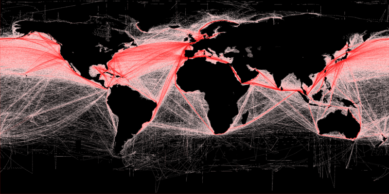
English: Shipping density (commercial). A Global Map of Human Impacts to Marine Ecosystems, showing relative density (in color) against a black background. Scale: 1 km. More details available at: http://spatial-analyst.net/worldmaps/shipping.rdc |
| Datums | |
| Avots |
Own work using:
|
| Autors | Grolltech (derived from Hengl (derived from B.S. Halpern)) |
| Citas versijas |
Šis fails tika iegūts no: Shipping routes.png:  |
| Atsauce (required by the license) | B.S. Halpern (T. Hengl; D. Groll) / Wikimedia Commons / |
Licence
Es, šī darba autortiesību īpašnieks, publicēju to saskaņā ar šo licenci:
Šis fails tiek izplatīts saskaņā ar licences Creative Commons Atsauce-Līdzīgi Noteikumi 3.0 Vispārējiem noteikumiem.
- Jūs varat brīvi:
- koplietot – kopēt, izplatīt un pārraidīt darbu
- remiksēt – pielāgot darbu
- Saskaņā ar šādiem nosacījumiem:
- atsaucoties – Tev ir jānorāda autors, saite uz licenci un to, vai veiktas kādas izmaiņas. To var darīt jebkādā saprātīgā veidā, bet ne tādā, kas norādītu, ka licencētājs atbalsta tevi vai veidu, kā tu izmanto šo darbu.
- nemainot licenci – Ja tu miksē, pārveido vai izmanto materiālu, tev savs devums jāpublicē ar to pašu vai saderīgu licenci kā oriģināls.
Faila hronoloģija
Uzklikšķini uz datums/laiks kolonnā esošās saites, lai apskatītos, kā šis fails izskatījās tad.
| Datums/Laiks | Attēls | Izmēri | Dalībnieks | Komentārs | |
|---|---|---|---|---|---|
| tagadējais | 2013. gada 16. februāris, plkst. 21.43 | | 3 600 × 1 800 (2,63 MB) | Grolltech | increase saturation and contrast |
| 2012. gada 19. marts, plkst. 18.26 |  | 3 600 × 1 800 (1,13 MB) | Grolltech | ||
| 2012. gada 19. marts, plkst. 18.25 |  | 3 600 × 1 800 (1,13 MB) | Grolltech |
Faila lietojums
Šo failu izmanto šajā 1 lapā:
Globālais faila lietojums
Šīs Vikipēdijas izmanto šo failu:
- Izmantojums ar.wikipedia.org
- Izmantojums bn.wikipedia.org
- Izmantojums cs.wikipedia.org
- Izmantojums da.wikipedia.org
- Izmantojums de.wikipedia.org
- Izmantojums en.wikipedia.org
- Izmantojums en.wikibooks.org
- Izmantojums es.wikipedia.org
- Izmantojums fa.wikipedia.org
- Izmantojums fi.wikipedia.org
- Izmantojums fr.wikipedia.org
- Izmantojums fr.wikiversity.org
- Izmantojums gl.wikipedia.org
- Izmantojums he.wikipedia.org
- Izmantojums hu.wikipedia.org
- Izmantojums ia.wikipedia.org
- Izmantojums id.wikipedia.org
- Izmantojums it.wikibooks.org
- Izmantojums ja.wikipedia.org
- Izmantojums ko.wikipedia.org
- Izmantojums mn.wikipedia.org
- Izmantojums ms.wikipedia.org
- Izmantojums pt.wikipedia.org
- Izmantojums ru.wikipedia.org
- Izmantojums uk.wikipedia.org
- Izmantojums uz.wikipedia.org
- Izmantojums vi.wikipedia.org
- Izmantojums www.wikidata.org
- Izmantojums zh.wikipedia.org
Skatīt šī faila pilno globālo izmantojumu.