
Attēls:Sikkim locator map.svg

Size of this PNG preview of this SVG file: 424 × 600 pikseļi. Citi izmēri: 170 × 240 pikseļi | 339 × 480 pikseļi | 543 × 768 pikseļi | 724 × 1 024 pikseļi | 1 448 × 2 048 pikseļi | 1 595 × 2 256 pikseļi.
Sākotnējais fails (SVG fails, definētais izmērs 1 595 × 2 256 pikseļi, faila izmērs: 244 KB)
| Šis fails ir no Vikikrātuves. Tā apraksts no attēla lapas Vikikrātuvē ir parādīts zemāk. Vikikrātuve ir brīvi licencēta failu krātuve. Tu vari tai palīdzēt. |
| Nosaukums |
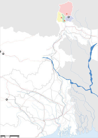
Sikkim locator map |
||
| Apraksts |
Map of w:Sikkim with road and rail lines. Equirectangular projection. Geographic limits of the map: top=28.15, bottom=21.48, left=84.99, right=90.15. |
||
| Datums | |||
| Avots |
Paša darbs |
||
| Izveidotājs |
|
||
| Atļauja: (Šī faila izmantošana citur) |
Es, šī darba autortiesību īpašnieks, publicēju to saskaņā ar šo licenci: Šis fails tiek izplatīts saskaņā ar licences Creative Commons Atsauce-Līdzīgi Noteikumi 3.0 Vispārējiem noteikumiem.
|
||
| Geotemporal data | |||
| Attēlotais datums | second half of 20 century un 21 century | ||
| Georeferencing | If inappropriate please set warp_status = skip to hide. | ||
| Archival data | |||
| Piezīmes | Part of WikiProject India Maps | ||
Faila hronoloģija
Uzklikšķini uz datums/laiks kolonnā esošās saites, lai apskatītos, kā šis fails izskatījās tad.
| Datums/Laiks | Attēls | Izmēri | Dalībnieks | Komentārs | |
|---|---|---|---|---|---|
| tagadējais | 2007. gada 12. maijs, plkst. 12.58 | | 1 595 × 2 256 (244 KB) | Planemad | border fix |
| 2007. gada 7. maijs, plkst. 22.20 |  | 1 595 × 2 256 (252 KB) | Planemad | border | |
| 2007. gada 7. maijs, plkst. 22.14 |  | 1 595 × 2 256 (245 KB) | Planemad | {{WikiProject_India_Maps |Title=Gujarat locator map.svg locator map |Description=Map of w:Gujarat locator map.svg with road and rail lines. |Source= |Date=May 2007 |Author=w:user:Planemad }} Category:WikiProject India State Maps |
Faila lietojums
Šo failu izmanto šajā 1 lapā:
Globālais faila lietojums
Šīs Vikipēdijas izmanto šo failu:
- Izmantojums as.wikipedia.org
- Izmantojums be.wikipedia.org
- Izmantojums de.wikipedia.org
- Izmantojums dty.wikipedia.org
- Izmantojums en.wikipedia.org
- Izmantojums es.wikipedia.org
- Izmantojums fa.wikipedia.org
- Izmantojums gu.wikipedia.org
- Izmantojums hi.wikipedia.org
- Izmantojums mai.wikipedia.org
- Izmantojums ml.wikipedia.org
- Izmantojums ms.wikipedia.org
- Izmantojums or.wikipedia.org
- Izmantojums pam.wikipedia.org
- Izmantojums pnb.wikipedia.org
- Izmantojums sw.wikipedia.org
- Izmantojums ta.wikipedia.org
- Izmantojums uk.wikipedia.org
- Izmantojums vi.wikipedia.org
- Izmantojums yo.wikipedia.org