
Attēls:Wake Island.png

Šī priekšskata izmērs: 597 × 600 pikseļi. Citi izmēri: 239 × 240 pikseļi | 631 × 634 pikseļi.
Sākotnējais fails (631 × 634 pikseļi, faila izmērs: 307 KB, MIME tips: image/png)
| Šis fails ir no Vikikrātuves. Tā apraksts no attēla lapas Vikikrātuvē ir parādīts zemāk. Vikikrātuve ir brīvi licencēta failu krātuve. Tu vari tai palīdzēt. |
|
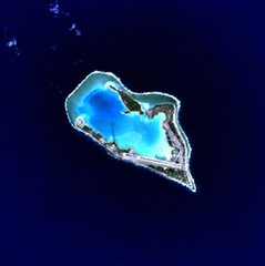
This is an image of a place or building that is listed on the National Register of Historic Places in the United States of America. Its reference number is 85002726. |
Wake Island - NASA NLT Landsat 7 (Visible Color) Satellite Image
| This file is in the public domain in the United States because it was solely created by NASA. NASA copyright policy states that "NASA material is not protected by copyright unless noted". (See Template:PD-USGov, NASA copyright policy page or JPL Image Use Policy.) | ||
 |
Warnings:
|
| Object location | | View this and other nearby images on: OpenStreetMap |
|---|
Faila hronoloģija
Uzklikšķini uz datums/laiks kolonnā esošās saites, lai apskatītos, kā šis fails izskatījās tad.
| Datums/Laiks | Attēls | Izmēri | Dalībnieks | Komentārs | |
|---|---|---|---|---|---|
| tagadējais | 2005. gada 10. aprīlis, plkst. 18.05 | | 631 × 634 (307 KB) | Bollar | Wake Island - NASA NLT Landsat 7 (Visible Color) Satellite Image {{PD-USGov-NASA}} |
Faila lietojums
Šo failu izmanto šajā 1 lapā:
Globālais faila lietojums
Šīs Vikipēdijas izmanto šo failu:
- Izmantojums af.wikipedia.org
- Izmantojums als.wikipedia.org
- Izmantojums ast.wikipedia.org
- Izmantojums cr.wikipedia.org
- Izmantojums da.wikipedia.org
- Izmantojums de.wikipedia.org
- Izmantojums en.wikipedia.org
- Izmantojums es.wikipedia.org
- Izmantojums et.wikipedia.org
- Izmantojums eu.wikipedia.org
- Izmantojums fi.wikipedia.org
- Izmantojums frp.wikipedia.org
- Izmantojums frr.wikipedia.org
- Izmantojums fr.wikipedia.org
- Izmantojums gl.wikipedia.org
- Izmantojums hi.wikipedia.org
- Izmantojums id.wikipedia.org
- Izmantojums is.wikipedia.org
- Izmantojums it.wikipedia.org
- Izmantojums ja.wikinews.org
- Izmantojums jv.wikipedia.org
- Izmantojums ko.wikipedia.org
- Izmantojums la.wikipedia.org
- Izmantojums ms.wikipedia.org
- Izmantojums mt.wikipedia.org
- Izmantojums no.wikipedia.org
- Izmantojums pap.wikipedia.org
- Izmantojums pl.wiktionary.org
- Izmantojums pt.wikipedia.org
- Izmantojums ro.wikipedia.org
Skatīt šī faila pilno globālo izmantojumu.