
Attēls:Watkins Glen International Track Map.svg

Size of this PNG preview of this SVG file: 450 × 229 pikseļi. Citi izmēri: 320 × 163 pikseļi | 640 × 326 pikseļi | 1 024 × 521 pikseļi | 1 280 × 651 pikseļi | 2 560 × 1 303 pikseļi.
Sākotnējais fails (SVG fails, definētais izmērs 450 × 229 pikseļi, faila izmērs: 60 KB)
| Šis fails ir no Vikikrātuves. Tā apraksts no attēla lapas Vikikrātuvē ir parādīts zemāk. Vikikrātuve ir brīvi licencēta failu krātuve. Tu vari tai palīdzēt. |
Kopsavilkums
| Apraksts |
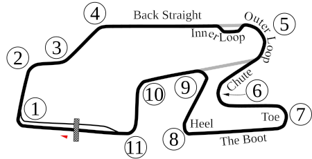
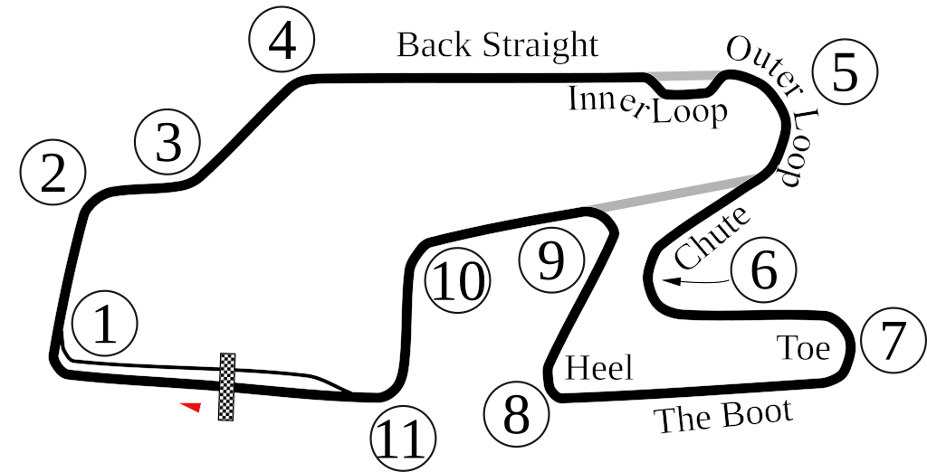
English: Vectorized old version of Image:Watkins Glen International Circuit Map.png. New version also adds the bus stop. |
| Datums | 6-5-2008 |
| Avots | Paša darbs |
| Autors | Will Pittenger |
| Citas versijas |
 |
| Camera location | | View this and other nearby images on: OpenStreetMap |
|---|
Licence
| I, the copyright holder of this work, release this work into the public domain. This applies worldwide. In some countries this may not be legally possible; if so: I grant anyone the right to use this work for any purpose, without any conditions, unless such conditions are required by law. |
Faila hronoloģija
Uzklikšķini uz datums/laiks kolonnā esošās saites, lai apskatītos, kā šis fails izskatījās tad.
| Datums/Laiks | Attēls | Izmēri | Dalībnieks | Komentārs | |
|---|---|---|---|---|---|
| tagadējais | 2009. gada 16. oktobris, plkst. 01.33 | | 450 × 229 (60 KB) | Spyder Monkey | Corrected corner numbers, converted text into paths for thumbnail display |
| 2009. gada 16. oktobris, plkst. 01.26 |  | 450 × 229 (37 KB) | Spyder Monkey | corrected corner names (inner loop, outer loop); added "Heel" of the boot | |
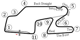
| 2008. gada 6. jūnijs, plkst. 08.29 |  | 450 × 229 (77 KB) | Will Pittenger | Updated version that displays the text on paths that were supposed to be there. If you need to edit that text, please edit the older version. | |
| 2008. gada 6. jūnijs, plkst. 08.22 |  | 450 × 229 (36 KB) | Will Pittenger | {{Information |Description={{en|1=Vectorized old version of Image:Watkins Glen International Circuit Map.png. New version also adds the bus stop.}} |Source=Own work by uploader |Author=Will Pittenger |Date=6-5-2008 |Permissio |
Faila lietojums
Šo failu izmanto šajā 1 lapā:
Globālais faila lietojums
Šīs Vikipēdijas izmanto šo failu:
- Izmantojums af.wikipedia.org
- Izmantojums ast.wikipedia.org
- Izmantojums bn.wikipedia.org
- Izmantojums de.wikipedia.org
- Izmantojums en.wikipedia.org
- Watkins Glen International
- 1999 FIA GT Watkins Glen 3 Hours
- 2007 Camping World Watkins Glen Grand Prix
- 6 Hours of Watkins Glen
- 2008 Camping World Indy Grand Prix at the Glen
- 2009 Camping World Grand Prix at the Glen
- List of IMSA GT Championship circuits
- 2009 Six Hours of Watkins Glen
- 2009 Crown Royal 200 at the Glen
- List of IndyCar Series racetracks
- Crown Royal 200 at the Glen
- 2010 Camping World Grand Prix at The Glen
- List of GT World Challenge America circuits
- 2016 IndyCar Grand Prix at The Glen
- 2017 IndyCar Grand Prix at The Glen
- List of IMSA SportsCar Championship circuits
- 2019 6 Hours of The Glen
- 2017 6 Hours of The Glen
- 2021 6 Hours of The Glen
- 2021 WeatherTech 240 at The Glen
- 2022 Sahlen's Six Hours of The Glen
- 2018 6 Hours of The Glen
- 2023 Sahlen's Six Hours of The Glen
- Izmantojums es.wikipedia.org
- Izmantojums eu.wikipedia.org
- Izmantojums fa.wikipedia.org
- Izmantojums fi.wikipedia.org
- Izmantojums fr.wikipedia.org
- Izmantojums hr.wikipedia.org
- Izmantojums hu.wikipedia.org
- Izmantojums id.wikipedia.org
Skatīt šī faila pilno globālo izmantojumu.