
Attēls:Chquel-map-fr.png
Augstāka izšķirtspēja nav pieejama.
Chquel-map-fr.png (348 × 352 pikseļi, faila izmērs: 145 KB, MIME tips: image/png)
| Šis fails ir no Vikikrātuves. Tā apraksts no attēla lapas Vikikrātuvē ir parādīts zemāk. Vikikrātuve ir brīvi licencēta failu krātuve. Tu vari tai palīdzēt. |
Kopsavilkums
| Camera location | | View this and other nearby images on: OpenStreetMap |
|---|
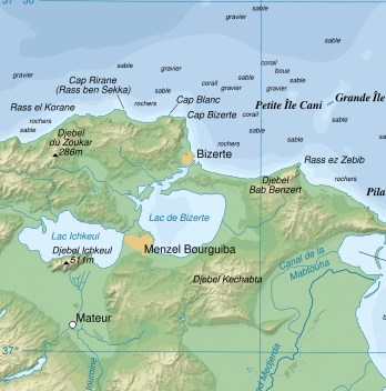
| Apraksts | Topographic map in French of the Gulf of Tunis, Tunisia, with indication of the nature of the sea bottom |
| Datums | |
| Avots |
Own work ; Topographic map : NASA Shuttle Radar Topography Mission (SRTM3 v.2) (public domain) edited with dlgv32 Pro and vectorized with Inkscape ; UTM projection ; WGS84 datum ; shaded relief (composite image of N-W, W and N lightning positions) ; References used for bathymetry and additional data : * 1:250,000 U.S. Army maps (printed 1956) ; * Google Earth ; * Locator map : Image:Tunisia.svg (modified) created by Philip Ronan (in PD) Approximate scale of topographic data and shore / lakes limits : 1:372,000 ; Note : The shaded relief is a raster image embedded in the SVG file which increases its size. If you want a lighter map for other purposes, delete the shaded relief image in your file. |
| Autors | Eric Gaba (Sting) |
| Atļauja: (Šī faila izmantošana citur) |
Attribution and Share-Alike required |
base source: http://commons.wikimedia.org/wiki/Image:Tunis_Gulf_topo_map-fr.svg
Français : * Sujet : Carte topographique en français du Golfe de Tunis, avec indication de la nature des fonds marins ;
- Sources : Création personnelle
- Données topographiques : NASA Shuttle Radar Topography Mission (SRTM3 v.2) (domaine public) édité avec dlgv32 Pro et vectorisé avec Inkscape ; projection UTM ; WGS84 datum ; relief ombré (image composite d'éclairages du N-O, O et N) ;
- Références utilisées pour la bathymétrie et les données complémentaires :
- Cartes au 1:250 000e de l'U.S. Army (imprimées en 1956) ;
- Google Earth ;
- Carte de localisation : Image:Tunisia.svg (modifiée) créée par Philip Ronan dans le domaine public ;
- Échelle approximative : 1:372 000 (données topographiques et tracés des côtes / lacs) ;
- Note : Le relief ombré est une image bitmap encapsulée dans le fichier SVG qui augmente son poids. Si vous avez besoin d'une carte plus légère pour d'autres utilisations, supprimez l'image du relief ombré dans votre fichier ;
- Auteur : Eric Gaba (fr:Sting) ;
- Date : Octobre 2007.
Licence
Es, šī darba autortiesību īpašnieks, publicēju to saskaņā ar šīm licencēm:

|
Ir dota atļauja kopēt, izplatīt un/vai pārveidot šo dokumentu saskaņā ar GNU brīvās dokumentācijas licences, versijas 1.2 vai jebkuras vēlākas versijas, ko publiskojis Brīvās programmatūras fonds nosacījumiem; bez nemainīgajām sadaļā, priekšējā un aizmugurēja'vāka tekstiem. Licences kopija ir iekļauta sadaļā ar nosaukumu GNU brīvās dokumentācijas licence. |
This file is licensed under the Creative Commons Attribution-Share Alike 3.0 Unported, 2.5 Generic, 2.0 Generic and 1.0 Generic license.
- Jūs varat brīvi:
- koplietot – kopēt, izplatīt un pārraidīt darbu
- remiksēt – pielāgot darbu
- Saskaņā ar šādiem nosacījumiem:
- atsaucoties – Tev ir jānorāda autors, saite uz licenci un to, vai veiktas kādas izmaiņas. To var darīt jebkādā saprātīgā veidā, bet ne tādā, kas norādītu, ka licencētājs atbalsta tevi vai veidu, kā tu izmanto šo darbu.
- nemainot licenci – Ja tu miksē, pārveido vai izmanto materiālu, tev savs devums jāpublicē ar to pašu vai saderīgu licenci kā oriģināls.
Jūs varat izvēlēties licenci pēc jūsu vēlmes.
Faila hronoloģija
Uzklikšķini uz datums/laiks kolonnā esošās saites, lai apskatītos, kā šis fails izskatījās tad.
| Datums/Laiks | Attēls | Izmēri | Dalībnieks | Komentārs | |
|---|---|---|---|---|---|
| tagadējais | 2008. gada 17. jūlijs, plkst. 03.18 | | 348 × 352 (145 KB) | Ori~ | {{Information |Description= |Source= |Date= |Author= |Permission= |other_versions= }} |
| 2008. gada 17. jūlijs, plkst. 03.16 |  | 849 × 768 (699 KB) | Ori~ | base source: http://commons.wikimedia.org/wiki/Image:Tunis_Gulf_topo_map-fr.svg == Summary == {{Location|37|00|00|N|10|30|00|E|scale:500000}} {{Information |Description=Topographic map in French of the Gulf of Tunis, Tunisia, with i |
Faila lietojums
Šo failu izmanto šajā 1 lapā:
Globālais faila lietojums
Šīs Vikipēdijas izmanto šo failu:
- Izmantojums et.wikipedia.org
- Izmantojums he.wikipedia.org
- Izmantojums sv.wikipedia.org