Attēls:Europe map 1648.PNG
Lapas saturs netiek atbalstīts citās valodās.
Vikipēdijas lapa

Sākotnējais fails(1 894 × 1 367 pikseļi, faila izmērs: 195 KB, MIME tips: image/png)

This historical map image could be re-created using vector graphics as an SVG file. This has several advantages; see Commons:Media for cleanup for more information. If an SVG form of this image is available, please upload it and afterwards replace this template with {{vector version available|new image name}}.


It is recommended to name the SVG file “Europe map 1648.svg”—then the template Vector version available (or Vva) does not need the new image name parameter.

Kopsavilkums

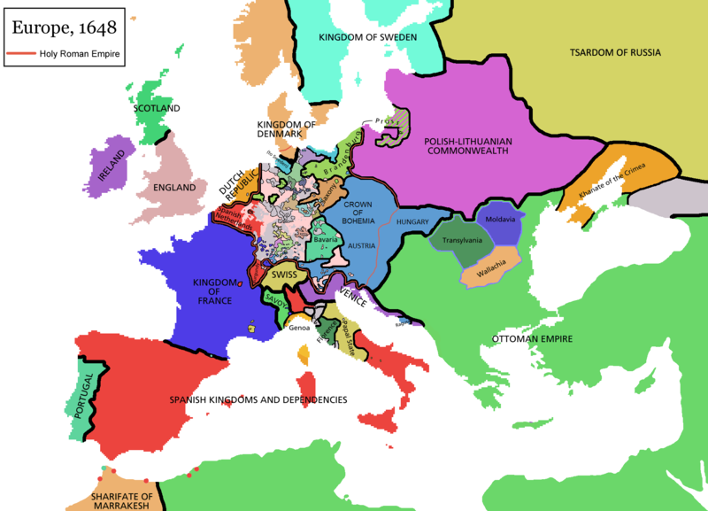
Map of Europe in 1648 (at the end of the Thirty Years War), based on free map of europe Image:BlankMap-Europe.png. Red line marks the border of the Holy Roman Empire. Information from Penguin atlas of modern history. (what year?)

Maps of the history of Europe
BCE
aC

Weichselian ice age (c. 113,000–9700) · Neolithic expansion (c. 7000–4500) · Middle Neolithic (c. 4500–4000) · Late Neolithic (c. 4000–3000) · Copper Age – Corded Ware culture (c. 2900–2350) · Copper Age – Bellbeaker culture (c. 2800–1800) · Early Bronze Age – Unetice culture (c. 2300–1600) · Late Bronze Age – Urnfield culture (c. 1300—750) · Migrations (c. 1000–100) · Hallstatt & La Tène cultures (c. 800–100) · Roman Republic (510–40) · 220 · 218 · 200 · 201–100 · 58 · 49 · 39 · 30 BCE–6 CE


CE
dC

14 · 14–37 · 60 · 60 · 69 · 80 · Migrations 100–500 · 117 · 117 · 125 · Migrations 150–774 · Economy 180 · 271 · 293–305 · 337 · 395 · c. 395 · 400 · 400 · 450 · 457–61 · 476 · 480 · Franks 481–814 · Early Slavs 500–700 · 500 · 526 · 526–600 · Christianisation to 600 · c. 550 · 650 · Pontic Steppe 650 · 665 · 800 · Vikings 800–1050 · 814 · 843–70 · 850 · 900 · 912 · 998 · 1000 · 1000 · 1054 · 1092 · First Crusade 1095–99 · 1097 · 1135 · 1142 · 1147–49 · 1190 · 1190 · 1250 · c. 1250 · 1301-1400 · 1301-1400 · 1328 · 1345 · Black Plague 1347–51 · 1360 · 1400 · Trade routes c. 1400 · 1430 · 1470 · 1490 · 1492 · 1500 · 1519 · 1550 · 1560 · Religion 1560 · Religion 1600 · Religion 1618 · 1618–48 · 1648 · 1683 · 1700 · 1701 · 1708 · 1714 · 1721 · 1725–30 · 1739–1740 · 1740 · 1748–66 · 1783–1792 · 1787 · 1787 · 1789 · 1799 · 1812 · 1812 · 1812 · 1812 · 1813 · 1815 · 1815 · 1815 · 1818 · Ottoman Empire 1830–1923 · 1848–49 · 1861 · 1867 · 1871 · 1878 · 1890 · 1905 · 1911 · 1914 · 1914 · 1919 · 1919–29 · 1923 · 1929 · 1930 · 1940 · 1941–42 · 1942–45 · Cold War 1947–91 · 1950 · 1993–2006 · 2006 to date

(this template: · view · discuss )


Licence

GNU head Ir dota atļauja kopēt, izplatīt un/vai pārveidot šo dokumentu saskaņā ar GNU brīvās dokumentācijas licences, versijas 1.2 vai jebkuras vēlākas versijas, ko publiskojis Brīvās programmatūras fonds nosacījumiem; bez nemainīgajām sadaļā, priekšējā un aizmugurēja'vāka tekstiem. Licences kopija ir iekļauta sadaļā ar nosaukumu GNU brīvās dokumentācijas licence.
w:en:Creative Commons
atsaucoties nemainot licenci
Šis fails tiek izplatīts saskaņā ar licences Creative Commons Atsauce-Līdzīgi Noteikumi 3.0 Vispārējiem noteikumiem.
Jūs varat brīvi:
  • koplietot – kopēt, izplatīt un pārraidīt darbu
  • remiksēt – pielāgot darbu
Saskaņā ar šādiem nosacījumiem:
  • atsaucoties – Tev ir jānorāda autors, saite uz licenci un to, vai veiktas kādas izmaiņas. To var darīt jebkādā saprātīgā veidā, bet ne tādā, kas norādītu, ka licencētājs atbalsta tevi vai veidu, kā tu izmanto šo darbu.
  • nemainot licenci – Ja tu miksē, pārveido vai izmanto materiālu, tev savs devums jāpublicē ar to pašu vai saderīgu licenci kā oriģināls.
This licensing tag was added to this file as part of the GFDL licensing update.

derivative works

Derivative works of this file:

Captions

Pievieno vienas rindiņas aprakstu, ko šis fails attēlo

Šajā failā attēlotais

attēlo

image/png

Faila hronoloģija

Uzklikšķini uz datums/laiks kolonnā esošās saites, lai apskatītos, kā šis fails izskatījās tad.

(Jaunākās | Senākās) Skatīt (10 jaunākas | ) (10 | 20 | 50 | 100 | 250 | 500 vienā lapā).
Datums/LaiksAttēlsIzmēriDalībnieksKomentārs
tagadējais2021. gada 14. aprīlis, plkst. 12.442021. gada 14. aprīlis, plkst. 12.44 versijas sīktēls1 894 × 1 367 (195 KB)TenanReverted to version as of 16:09, 12 October 2017 (UTC) See discussion
2021. gada 9. marts, plkst. 13.472021. gada 9. marts, plkst. 13.47 versijas sīktēls1 894 × 1 367 (210 KB)TTBCamhReverted to version as of 17:18, 20 September 2018 (UTC). I don't know why Raderich is saying this is an arbitrary change—Catalonia was under the possession of the French king in 1648, following the Catalan Revolt of 1640. This map is correct and the previous one is incorrect.
2018. gada 25. septembris, plkst. 15.122018. gada 25. septembris, plkst. 15.12 versijas sīktēls1 894 × 1 367 (195 KB)RaderichReverted to version as of 21:15, 18 September 2018 (UTC) Undone arbitrary changes. Revert to correct map as uploaded by its creator Roke~commonswiki
2018. gada 20. septembris, plkst. 20.182018. gada 20. septembris, plkst. 20.18 versijas sīktēls1 894 × 1 367 (210 KB)AmbroiseLThe Catalan counties were French since they proclaimed Louis XIV of France as their king. They wanted to be French in order not to obey the king of Spain anymore. Courland was a quite free vassal state of Poland. The reverted version doesn't show it. The reverted version also doesn't show the Venetian islands in the Adriatic Sea, and the Algerian towns that France occupied. Hence, I re-revert to the more precise version.
2018. gada 19. septembris, plkst. 00.152018. gada 19. septembris, plkst. 00.15 versijas sīktēls1 894 × 1 367 (195 KB)RaderichReverted to version as of 16:09, 12 October 2017 (UTC)
2018. gada 19. jūlijs, plkst. 13.452018. gada 19. jūlijs, plkst. 13.45 versijas sīktēls1 894 × 1 367 (210 KB)AmbroiseLReverted to version as of 12:06, 20 January 2017 (UTC) — reverted to the version with fixed names, my mistake
2018. gada 19. jūlijs, plkst. 13.372018. gada 19. jūlijs, plkst. 13.37 versijas sīktēls1 894 × 1 367 (150 KB)AmbroiseLReverted to version as of 10:33, 24 September 2016 (UTC)
2017. gada 12. oktobris, plkst. 19.092017. gada 12. oktobris, plkst. 19.09 versijas sīktēls1 894 × 1 367 (195 KB)Reverted to version as of 12:42, 9 September 2016 (UTC) why is Catalonia French? Not shown as such on File:Europe_1648_westphal_1884.jpg
2017. gada 20. janvāris, plkst. 15.062017. gada 20. janvāris, plkst. 15.06 versijas sīktēls1 894 × 1 367 (210 KB)FakirbakirNames of Austria, Bohemia and Hungary are fixed.
2016. gada 24. septembris, plkst. 13.332016. gada 24. septembris, plkst. 13.33 versijas sīktēls1 894 × 1 367 (150 KB)AmbroiseLAdjunction of polish-lithuanian vassal state of Courland
(Jaunākās | Senākās) Skatīt (10 jaunākas | ) (10 | 20 | 50 | 100 | 250 | 500 vienā lapā).

Šo failu neizmanto nevienā lapā.

Globālais faila lietojums

Šīs Vikipēdijas izmanto šo failu:

Skatīt šī faila pilno globālo izmantojumu.

Metadati