Attēls:Map-Germany-1945.svg
Lapas saturs netiek atbalstīts citās valodās.
Vikipēdijas lapa

Sākotnējais fails(SVG fails, definētais izmērs 3 492 × 2 966 pikseļi, faila izmērs: 726 KB)

Kopsavilkums

Apraksts
العربية: حدود المناطق المحتلة في ألمانيا عام 1957. الاراضي شرق خط نيس تحت السيطرة البولندية والسوفييتية، تظهر بلون ابيض. برلين منطقة مسيطر عليها من عدة بلدان داخل المنطقة السوفييتة.
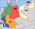
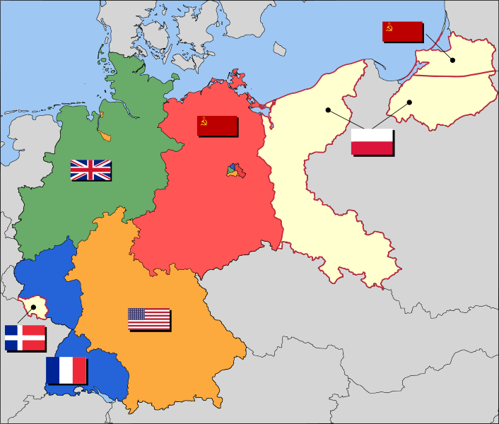
English: Occupation zone borders in Germany, 1947. The territories east of the Oder-Neisse line, under Polish and Soviet administration/annexation, are shown as cream as is the likewise detached Saar protectorate. Berlin is the multinational area within the Soviet zone.
Français : Carte des zones d'occupation de l'Allemagne : le protectorat français de la Sarre apparait en blanc-crème, comme la Silésie, la Poméranie et les autres régions allemandes orientales annexées par la Pologne et l'Union Soviétique.
Deutsch: Grenzen der Besatzungszonen in Deutschland, 1947. Die Gebiete östlich der Oder-Neiße-Grenze, unter polnischer und sowjetischer Verwaltung/Annexion, sowie das Saar-Protektorat sind cremefarben dargestellt. Berlin ist ein multinationales Gebiet inmitten der sowjetischen Besatzungszone.
Datums 2008. gada 17. marts (original upload date)
Avots Based on map data of the IEG-Maps project (Andreas Kunz, B. Johnen and Joachim Robert Moeschl: University of Mainz) - www.ieg-maps.uni-mainz.de.
Autors User:52 Pickup
SVG veidošana
InfoField
 
The source code of this SVG is invalid due to 11 errors.
 
This W3C-invalid map was created with Inkscape…important.

Licence

w:en:Creative Commons
atsaucoties nemainot licenci
Šis fails tiek izplatīts saskaņā ar licences Creative Commons Atsauce-Līdzīgi Noteikumi 2.5 Vispārējiem noteikumiem.
Jūs varat brīvi:
  • koplietot – kopēt, izplatīt un pārraidīt darbu
  • remiksēt – pielāgot darbu
Saskaņā ar šādiem nosacījumiem:
  • atsaucoties – Tev ir jānorāda autors, saite uz licenci un to, vai veiktas kādas izmaiņas. To var darīt jebkādā saprātīgā veidā, bet ne tādā, kas norādītu, ka licencētājs atbalsta tevi vai veidu, kā tu izmanto šo darbu.
  • nemainot licenci – Ja tu miksē, pārveido vai izmanto materiālu, tev savs devums jāpublicē ar to pašu vai saderīgu licenci kā oriģināls.

Original upload log

Transferred from en.wikipedia to Commons by Broadbeer using CommonsHelper.

The original description page was here. All following user names refer to en.wikipedia.
  • 2008-03-17 19:50 52 Pickup 3492×2966× (760290 bytes) Changes to fill and border colours. Made differences clearer between occupation zones and eventual territorial losses.
  • 2007-08-31 14:57 52 Pickup 3492×2966× (755561 bytes) New version: regions placed under Polish and Soviet administration now presented slightly differently (borders instead of colour fill), Saar colour now only slightly different to French zone (still needs some work)
  • 2007-08-10 09:50 52 Pickup 3492×2966× (751829 bytes) oops, now with fixed image size
  • 2007-08-10 09:47 52 Pickup 744×1052× (751774 bytes) {{Information| |Description= Germany in the aftermath of World War II: 1 September 1945 |Source= Based on map data of the IEG-Maps project (Andreas Kunz, B. Johnen and Joachim Robert Moeschl: University of Mainz) - [http://www.ieg-maps.uni-mainz.de www.ie
Annotations
InfoField
This image is annotated: View the annotations at Commons

Captions

Pievieno vienas rindiņas aprakstu, ko šis fails attēlo
Occupation map of Germany after WW2

Šajā failā attēlotais

attēlo

17 marts 2008

Faila hronoloģija

Uzklikšķini uz datums/laiks kolonnā esošās saites, lai apskatītos, kā šis fails izskatījās tad.

Datums/LaiksAttēlsIzmēriDalībnieksKomentārs
tagadējais2017. gada 1. decembris, plkst. 07.372017. gada 1. decembris, plkst. 07.37 versijas sīktēls3 492 × 2 966 (726 KB)SammimackUpdated flags and colours
2015. gada 3. jūlijs, plkst. 17.132015. gada 3. jūlijs, plkst. 17.13 versijas sīktēls3 492 × 2 966 (728 KB)LichaoshengNew 48-Star US Flag from File:US flag 48 stars.svg
2015. gada 3. jūlijs, plkst. 17.002015. gada 3. jūlijs, plkst. 17.00 versijas sīktēls3 492 × 2 966 (742 KB)LichaoshengReverted to version as of 18:46, 8 October 2008
2012. gada 4. februāris, plkst. 18.192012. gada 4. februāris, plkst. 18.19 versijas sīktēls3 492 × 2 966 (742 KB)AnonMoosReverted to version as of 18:46, 8 October 2008 -- Kaliningrad had quite different status and fate from that of East Germany proper...
2012. gada 20. janvāris, plkst. 22.442012. gada 20. janvāris, plkst. 22.44 versijas sīktēls3 492 × 2 966 (742 KB)Sammy pomponKaliningrado is occuped by USSR.
2008. gada 8. oktobris, plkst. 21.462008. gada 8. oktobris, plkst. 21.46 versijas sīktēls3 492 × 2 966 (742 KB)File Upload Bot (Magnus Manske) {{BotMoveToCommons|en.wikipedia}} {{Information |Description={{en|Occupation zone borders in Germany, 1947. The territories east of the en:Oder-Neisse line, under Polish and Soviet administration/annexation, are shown as white as is the likewise det

Šo failu izmanto šajā 1 lapā:

Globālais faila lietojums

Šīs Vikipēdijas izmanto šo failu:

Skatīt šī faila pilno globālo izmantojumu.

Metadati