
Attēls:Muscovy 1390 1525.png
Augstāka izšķirtspēja nav pieejama.
Muscovy_1390_1525.png (440 × 425 pikseļi, faila izmērs: 135 KB, MIME tips: image/png)
| Šis fails ir no Vikikrātuves. Tā apraksts no attēla lapas Vikikrātuvē ir parādīts zemāk. Vikikrātuve ir brīvi licencēta failu krātuve. Tu vari tai palīdzēt. |
| Apraksts |
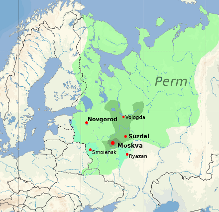
English: Territorial expansion of the Grand Duchy of Moscow, 1300–1547
Core territory of Muscovy, 1300
Territory of Vladimir-Suzdal, acquired by Muscovy by 1390
Territory acquired by 1505 (Ivan III)
Territory acquired by 1533 (Vasili III)
Modern national borders are shown for orientation. |
|||
| Datums | ||||
| Avots |
blank map: File:Europe location POR.png. Territorial boundaries based on File:Moscow1500.png, File:Kievan-rus-1015-1113-(en).png, File:Muscovy 1300-1462.png. See also File:Russia 1533-1896.gif. See talkpage for discussion of the sources used. Information on historical territory relies on maps uploaded by ru:Участник:Koryakov Yuri (2008). |
|||
| Autors | Dbachmann | |||
| Atļauja: (Šī faila izmantošana citur) |
derivative work based on the blank map by David Liuzzo.
|

.png)

|
This historical map image could be re-created using vector graphics as an SVG file. This has several advantages; see Commons:Media for cleanup for more information. If an SVG form of this image is available, please upload it and afterwards replace this template with
{{vector version available|new image name}}.
It is recommended to name the SVG file “Muscovy 1390 1525.svg”—then the template Vector version available (or Vva) does not need the new image name parameter. |
Faila hronoloģija
Uzklikšķini uz datums/laiks kolonnā esošās saites, lai apskatītos, kā šis fails izskatījās tad.
| Datums/Laiks | Attēls | Izmēri | Dalībnieks | Komentārs | |
|---|---|---|---|---|---|
| tagadējais | 2022. gada 23. janvāris, plkst. 19.20 | | 440 × 425 (135 KB) | Ориенталист | Reverted to version as of 16:40, 5 October 2020 (UTC) See File:Russo–Lithuanian Wars-1500 campaign-rus0.2.svg This territories became part of Russia during Ivan III |
| 2021. gada 2. decembris, plkst. 13.09 |  | 440 × 425 (170 KB) | Dbachmann | Reverted to version as of 13:12, 17 April 2011 (UTC) -- I am sorry, please explain the change, you cannot just say "more accurate" without changing the references to the sources this is based on. | |
| 2020. gada 5. oktobris, plkst. 19.40 |  | 440 × 425 (135 KB) | Ориенталист | More accurate | |
| 2011. gada 17. aprīlis, plkst. 16.12 |  | 440 × 425 (170 KB) | Dbachmann | update | |
| 2011. gada 17. aprīlis, plkst. 15.42 |  | 450 × 438 (212 KB) | Dbachmann | {{Information |Description ={{en|1=Grand Duchy of Moscow (Muscovy) between 1390 and 1547}} |Source =blank map: File:Europe location POR.png |Author =Dbachmann |Date =2011 |Permission = {{Copyrighted free use provided |
Faila lietojums
Šo failu izmanto šajā 1 lapā:
Globālais faila lietojums
Šīs Vikipēdijas izmanto šo failu:
- Izmantojums af.wikipedia.org
- Izmantojums arz.wikipedia.org
- Izmantojums ast.wikipedia.org
- Izmantojums ba.wikipedia.org
- Izmantojums be-tarask.wikipedia.org
- Izmantojums be.wikipedia.org
- Izmantojums ca.wikipedia.org
- Izmantojums ce.wikipedia.org
- Izmantojums cs.wikipedia.org
- Izmantojums cy.wikipedia.org
- Izmantojums da.wikipedia.org
- Izmantojums de.wikipedia.org
- Izmantojums el.wikipedia.org
- Izmantojums en.wikipedia.org
- Izmantojums en.wikibooks.org
- Izmantojums en.wiktionary.org
- Izmantojums eo.wikipedia.org
- Izmantojums es.wikipedia.org
- Izmantojums et.wikipedia.org
- Izmantojums eu.wikipedia.org
- Izmantojums fa.wikipedia.org
- Izmantojums fi.wikipedia.org
- Izmantojums fr.wikipedia.org
Skatīt šī faila pilno globālo izmantojumu.