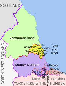
Attēls:North East England counties 2009 map.svg
Izskats

Size of this PNG preview of this SVG file: 482 × 599 pikseļi. Citi izmēri: 193 × 240 pikseļi | 386 × 480 pikseļi | 618 × 768 pikseļi | 824 × 1 024 pikseļi | 1 647 × 2 048 pikseļi | 1 082 × 1 345 pikseļi.
Sākotnējais fails (SVG fails, definētais izmērs 1 082 × 1 345 pikseļi, faila izmērs: 723 KB)
Faila hronoloģija
Uzklikšķini uz datums/laiks kolonnā esošās saites, lai apskatītos, kā šis fails izskatījās tad.
| Datums/Laiks | Attēls | Izmēri | Dalībnieks | Komentārs | |
|---|---|---|---|---|---|
| tagadējais | 2018. gada 14. augusts, plkst. 22.16 |  | 1 082 × 1 345 (723 KB) | Inops | change letters labelling the boroughs of Tyne and Wearfrom white to black. Hardly intelligible when thumbnailed otherwise |
| 2012. gada 5. maijs, plkst. 22.11 |  | 1 082 × 1 345 (723 KB) | Dr Greg | lighten black boundary line | |
| 2012. gada 2. maijs, plkst. 00.21 |  | 1 082 × 1 345 (723 KB) | Dr Greg | == {{int:filedesc}} == {{Information |Description={{en|Map of the North East England region of England, showing its counties and administrative districts. The county colours are the same as those in [[:File:English metropolitan... |
Faila lietojums
Šo failu izmanto šajā 1 lapā:
Globālais faila lietojums
Šīs Vikipēdijas izmanto šo failu:
- Izmantojums ar.wikipedia.org
- Izmantojums ca.wikipedia.org
- Izmantojums de.wikipedia.org
- Izmantojums en.wikipedia.org
- Izmantojums es.wikipedia.org
- Izmantojums fa.wikipedia.org
- Izmantojums fr.wikipedia.org
- Izmantojums hu.wikipedia.org
- Izmantojums ja.wikipedia.org
- Izmantojums mr.wikipedia.org
- Izmantojums pl.wikipedia.org
- Izmantojums pnb.wikipedia.org
- Izmantojums th.wikipedia.org
- Izmantojums ur.wikipedia.org
- Izmantojums vi.wikipedia.org
- Izmantojums vls.wikipedia.org
- Izmantojums zh-yue.wikipedia.org


