
Attēls:Prima tetrarchia Diocletianus.PNG

Šī priekšskata izmērs: 800 × 549 pikseļi. Citi izmēri: 320 × 220 pikseļi | 640 × 439 pikseļi | 1 024 × 703 pikseļi | 1 280 × 878 pikseļi | 2 036 × 1 397 pikseļi.
Sākotnējais fails (2 036 × 1 397 pikseļi, faila izmērs: 180 KB, MIME tips: image/png)
| Šis fails ir no Vikikrātuves. Tā apraksts no attēla lapas Vikikrātuvē ir parādīts zemāk. Vikikrātuve ir brīvi licencēta failu krātuve. Tu vari tai palīdzēt. |

|
This historical map image could be re-created using vector graphics as an SVG file. This has several advantages; see Commons:Media for cleanup for more information. If an SVG form of this image is available, please upload it and afterwards replace this template with
{{vector version available|new image name}}.
It is recommended to name the SVG file “Prima tetrarchia Diocletianus.svg”—then the template Vector version available (or Vva) does not need the new image name parameter. |
Kopsavilkums
| Apraksts |
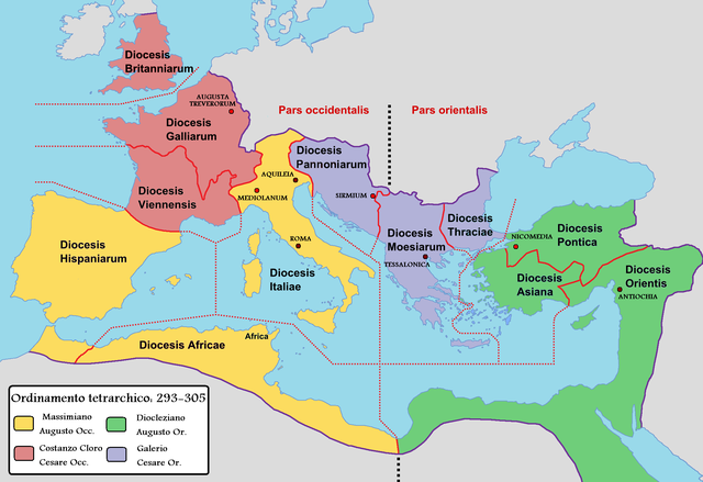
English: Map of the Roman Empire with dioceses created by Diocletien. Italiano: Mappa dell'Impero romano durante la prima tetrarchia di Diocleziano. |
||
| Datums | |||
| Avots |
|
||
| Autors |
|
Licence
Es, šī darba autortiesību īpašnieks, publicēju to saskaņā ar šo licenci:
| I, the copyright holder of this work, release this work into the public domain. This applies worldwide. In some countries this may not be legally possible; if so: I grant anyone the right to use this work for any purpose, without any conditions, unless such conditions are required by law. |
Original upload log
This image is a derivative work of the following images:
- File:Roman Empire with dioceses in 300 AD.png licensed with PD-self
- 2009-03-10T12:34:18Z Mandrak 2052x1414 (223180 Bytes) Erreurs corrigées.
- 2009-03-03T20:03:56Z Mandrak 2052x1414 (223409 Bytes) {{Information |Description={{en|1=Map of the Roman Empire with dioceses created by Diocletien.}} {{fr|1=Carte de l'Empire romain avec les diocèses créés par l'empereur Dioclétien.}} |Source=travail personnel (own work) |A
Uploaded with derivativeFX
Faila hronoloģija
Uzklikšķini uz datums/laiks kolonnā esošās saites, lai apskatītos, kā šis fails izskatījās tad.
| Datums/Laiks | Attēls | Izmēri | Dalībnieks | Komentārs | |
|---|---|---|---|---|---|
| tagadējais | 2022. gada 12. februāris, plkst. 07.42 | | 2 036 × 1 397 (180 KB) | Lojwe | Frame removed |
| 2011. gada 20. maijs, plkst. 19.21 |  | 2 069 × 1 434 (206 KB) | Cristiano64 | {{Information |Description={{en|1=Map of the Roman Empire with dioceses created by Diocletien.}} {{it|1=Mappa dell'Impero romano durante la prima tetrarchia di Diocléziano.}} |Source=*File:Roman_Empire_with_dioceses_in_300_AD.png |Date=2011-05-20 1 |
Faila lietojums
Šo failu izmanto šajā 1 lapā:
Globālais faila lietojums
Šīs Vikipēdijas izmanto šo failu:
- Izmantojums ast.wikipedia.org
- Izmantojums cv.wikipedia.org
- Izmantojums da.wikipedia.org
- Izmantojums de.wikipedia.org
- Izmantojums de.wikibooks.org
- Izmantojums de.wikiversity.org
- Izmantojums en.wikipedia.org
- Izmantojums es.wikipedia.org
- Izmantojums eu.wikipedia.org
- Izmantojums fr.wikipedia.org
- Izmantojums gl.wikipedia.org
- Izmantojums hu.wikipedia.org
- Izmantojums it.wikipedia.org
- Provincia (storia romana)
- Britannia (provincia romana)
- Legione romana
- Diocleziano
- Tetrarchia
- Aquincum
- Tunisia
- Massimiano
- Esercito romano
- Europa meridionale
- Sirmio
- Tarda antichità
- Fortezze legionarie romane
- Storia d'Italia
- Pannonia (provincia romana)
- Tracia (provincia romana)
- Gallia Comata
- Oriente (diocesi)
- Discussioni utente:Panairjdde/Cristiano64
- Ponto (diocesi)
- Africa (diocesi)
- Pannonia (diocesi)
- Tardo impero romano
Skatīt šī faila pilno globālo izmantojumu.