
Attēls:The Hump and Burma Road.png

Šī priekšskata izmērs: 800 × 569 pikseļi. Citi izmēri: 320 × 227 pikseļi | 640 × 455 pikseļi | 1 024 × 728 pikseļi | 1 120 × 796 pikseļi.
Sākotnējais fails (1 120 × 796 pikseļi, faila izmērs: 343 KB, MIME tips: image/png)
| Šis fails ir no Vikikrātuves. Tā apraksts no attēla lapas Vikikrātuvē ir parādīts zemāk. Vikikrātuve ir brīvi licencēta failu krātuve. Tu vari tai palīdzēt. |

|
This historical map image could be re-created using vector graphics as an SVG file. This has several advantages; see Commons:Media for cleanup for more information. If an SVG form of this image is available, please upload it and afterwards replace this template with
{{vector version available|new image name}}.
It is recommended to name the SVG file “The Hump and Burma Road.svg”—then the template Vector version available (or Vva) does not need the new image name parameter. |
Kopsavilkums
| Apraksts |
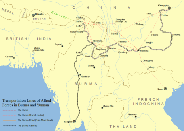
English: Transportation Lines of Allied Forces in Burma and Yunnan Province of China During World War II |
| Datums | |
| Avots | Paša darbs |
| Autors | SY |
Reference: Atlas of High School History (China Cartographic Publishing House)
Licence
Es, šī darba autortiesību īpašnieks, publicēju to saskaņā ar šo licenci:
This file is licensed under the Creative Commons Attribution-Share Alike 4.0 International license.
- Jūs varat brīvi:
- koplietot – kopēt, izplatīt un pārraidīt darbu
- remiksēt – pielāgot darbu
- Saskaņā ar šādiem nosacījumiem:
- atsaucoties – Tev ir jānorāda autors, saite uz licenci un to, vai veiktas kādas izmaiņas. To var darīt jebkādā saprātīgā veidā, bet ne tādā, kas norādītu, ka licencētājs atbalsta tevi vai veidu, kā tu izmanto šo darbu.
- nemainot licenci – Ja tu miksē, pārveido vai izmanto materiālu, tev savs devums jāpublicē ar to pašu vai saderīgu licenci kā oriģināls.
Faila hronoloģija
Uzklikšķini uz datums/laiks kolonnā esošās saites, lai apskatītos, kā šis fails izskatījās tad.
| Datums/Laiks | Attēls | Izmēri | Dalībnieks | Komentārs | |
|---|---|---|---|---|---|
| tagadējais | 2018. gada 16. februāris, plkst. 06.33 | | 1 120 × 796 (343 KB) | Seasonsinthesun | User created page with UploadWizard |
Faila lietojums
Šo failu izmanto šajā 1 lapā:
Globālais faila lietojums
Šīs Vikipēdijas izmanto šo failu:
- Izmantojums bg.wikipedia.org
- Izmantojums cs.wikipedia.org
- Izmantojums en.wikipedia.org
- Izmantojums eo.wikipedia.org
- Izmantojums fa.wikipedia.org
- Izmantojums id.wikipedia.org
- Izmantojums mnw.wikipedia.org
- Izmantojums ru.wikipedia.org
- Izmantojums sk.wikipedia.org
- Izmantojums zh.wikipedia.org