
Attēls:1850 Mitchell Map of Austria, Hungary and Transylvania - Geographicus - Austria-mitchell-1850.jpg

Šī priekšskata izmērs: 755 × 600 pikseļi. Citi izmēri: 302 × 240 pikseļi | 604 × 480 pikseļi | 967 × 768 pikseļi | 1 280 × 1 017 pikseļi | 2 560 × 2 033 pikseļi | 3 000 × 2 383 pikseļi.
Sākotnējais fails (3 000 × 2 383 pikseļi, faila izmērs: 2,31 MB, MIME tips: image/jpeg)
| Šis fails ir no Vikikrātuves. Tā apraksts no attēla lapas Vikikrātuvē ir parādīts zemāk. Vikikrātuve ir brīvi licencēta failu krātuve. Tu vari tai palīdzēt. |
| Samuel Augustus Mitchell: Austrian Empire.
( |
||||||||||||||||||||
|---|---|---|---|---|---|---|---|---|---|---|---|---|---|---|---|---|---|---|---|---|
| Izpildītājs |
|
|||||||||||||||||||
| Nosaukums |
Austrian Empire. |
|||||||||||||||||||
| Apraksts |
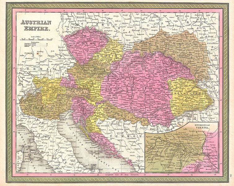
English: An extremely attractive example of S. A. Mitchell Sr.’s 1850 map of the Austrian Empire. Includes much of today's Austria, Hungary, Romania, Albania, Serbia and Croatia. Depicts the entire country color coded according to individual states. Lower right quadrant features an inset map of the Environs of Vienna. Surrounded by the green border common to Mitchell maps from the 1850s. Prepared by S. A. Mitchell for issued as plate no. 56 in the 1850 edition of his New Universal Atlas . |
|||||||||||||||||||
| Datums | 1850. gada (undated) | |||||||||||||||||||
| Izmēri | augstums: 12 in (30,4 cm); platums: 15 in (38,1 cm) | |||||||||||||||||||
| Accession number |
Geographicus link: Austria-mitchell-1850 |
|||||||||||||||||||
| Avots/Fotogrāfs |
Mitchell Sr., S. A.,A New Universal Atlas Containing Maps of the various Empires, Kingdoms, States and Republics Of The World. (1850 issue)
|
|||||||||||||||||||
| Atļauja: (Šī faila izmantošana citur) |
|
|||||||||||||||||||
Faila hronoloģija
Uzklikšķini uz datums/laiks kolonnā esošās saites, lai apskatītos, kā šis fails izskatījās tad.
| Datums/Laiks | Attēls | Izmēri | Dalībnieks | Komentārs | |
|---|---|---|---|---|---|
| tagadējais | 2011. gada 23. marts, plkst. 04.09 | | 3 000 × 2 383 (2,31 MB) | BotMultichillT | {{subst:User:Multichill/Geographicus |link=http://www.geographicus.com/P/AntiqueMap/Austria-mitchell-1850 |product_name=1850 Mitchell Map of Austria, Hungary and Transylvania |map_title=Austrian Empire. |description=An extremely attractive example of S. A |
Faila lietojums
Šo failu neizmanto nevienā lapā.
Globālais faila lietojums
Šīs Vikipēdijas izmanto šo failu:
- Izmantojums en.wikipedia.org
- Izmantojums es.wikipedia.org
- Izmantojums hr.wikipedia.org
- Izmantojums sh.wikipedia.org
- Izmantojums uk.wikipedia.org