
Attēls:Frankish Empire 481 to 814-en.svg

Size of this PNG preview of this SVG file: 792 × 600 pikseļi. Citi izmēri: 317 × 240 pikseļi | 634 × 480 pikseļi | 1 014 × 768 pikseļi | 1 280 × 969 pikseļi | 2 560 × 1 939 pikseļi | 1 591 × 1 205 pikseļi.
Sākotnējais fails (SVG fails, definētais izmērs 1 591 × 1 205 pikseļi, faila izmērs: 834 KB)
| Šis fails ir no Vikikrātuves. Tā apraksts no attēla lapas Vikikrātuvē ir parādīts zemāk. Vikikrātuve ir brīvi licencēta failu krātuve. Tu vari tai palīdzēt. |
Kopsavilkums
| Apraksts |
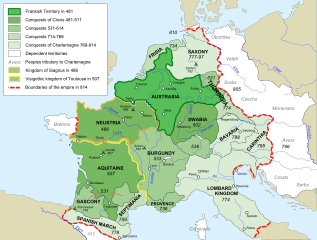
[] Afrikaans: Die veranderende strekking van die Frankiese Ryk van 481 tot 814. Alemannisch: S Frankeriich vo 481 bis 814. Bahasa Indonesia: Peta kebangkitan Kekaisaran Franka, dari tahun 481 hingga 814. Català: Mapa de l'expansió de l'Imperi Franc, de 481 a 814. Deutsch: Karte der Ausdehnung des Fränkischen Reichs 481 bis 814. English: Map of the rise of Frankish Empire, from 481 to 814. Español: Mapa de la expansión del Imperio Franco, entre 481 y 814. Euskara: Frankoen Inperioaren hedapenaren mapa, 481-814 urteen bitartean. Français : Carte de l'expansion de l'empire Franc, entre 481 et 814. Italiano: Carta dell'espansione dell'impero dei Franchi tra il 481 e il 814. Magyar: Frank Birodalom 481-814 Nederlands: Kaart van de opkomst van het Frankische Rijk, van 481 tot 814. Polski: Mapa rozwoju Imperium Franków w latach 481-814 Português: Mapa da expansão do Império Franco, entre 481 e 814. Română: Harta ascensiunii Imperiului franc, 481-814. Svenska: Karantanien i det frankiska riket (år 788 - 843). Ελληνικά: Η Φραγκική Αυτοκρατορία 481-814 Македонски: Карта на подемот на Франкското царство, од 481 до 814 г. Русский: Карта расширения империи франков, между 481 и 814. Українська: Карта розширення імперії Франків в період 481-814 рр. 日本語: カロリング朝の版図。 中文: 墨洛温王朝到加洛林王朝(481—814)的法兰克王国。 العربية : إمبراطوريَّة الفرنجة ما بين عاميّ 481 و814م |
| Datums | |
| Avots |
Own work using:
|
| Autors | Sémhur |
| Citas versijas |
Derivative works of this file: Frankish Empire 481 to 814-sr.svg
[]
|
| Camera location | | View this and other nearby images on: OpenStreetMap |
|---|

|
This SVG file contains embedded text that can be translated into your language, using any capable SVG editor, text editor or the SVG Translate tool. For more information see: About translating SVG files. |
This W3C-unspecified vector image was created with Inkscape .
Licence
Es, šī darba autortiesību īpašnieks, publicēju to saskaņā ar šīm licencēm:
| Copyleft: This work of art is free; you can redistribute it and/or modify it according to terms of the Free Art License. You will find a specimen of this license on the Copyleft Attitude site as well as on other sites. |
This file is licensed under the Creative Commons Attribution-Share Alike 3.0 Unported, 2.5 Generic, 2.0 Generic and 1.0 Generic license.
- Jūs varat brīvi:
- koplietot – kopēt, izplatīt un pārraidīt darbu
- remiksēt – pielāgot darbu
- Saskaņā ar šādiem nosacījumiem:
- atsaucoties – Tev ir jānorāda autors, saite uz licenci un to, vai veiktas kādas izmaiņas. To var darīt jebkādā saprātīgā veidā, bet ne tādā, kas norādītu, ka licencētājs atbalsta tevi vai veidu, kā tu izmanto šo darbu.
- nemainot licenci – Ja tu miksē, pārveido vai izmanto materiālu, tev savs devums jāpublicē ar to pašu vai saderīgu licenci kā oriģināls.
Jūs varat izvēlēties licenci pēc jūsu vēlmes.
Faila hronoloģija
Uzklikšķini uz datums/laiks kolonnā esošās saites, lai apskatītos, kā šis fails izskatījās tad.
| Datums/Laiks | Attēls | Izmēri | Dalībnieks | Komentārs | |
|---|---|---|---|---|---|
| tagadējais | 2012. gada 5. septembris, plkst. 21.10 | | 1 591 × 1 205 (834 KB) | Hel-hama | minor corrections |
| 2012. gada 5. septembris, plkst. 20.35 |  | 1 591 × 1 205 (844 KB) | Hel-hama | second attempt to upload file | |
| 2012. gada 2. septembris, plkst. 22.34 |  | 1 735 × 1 227 (331 KB) | Hel-hama | Reverted to version as of 05:50, 7 May 2012 | |
| 2012. gada 2. septembris, plkst. 22.30 |  | 1 796 × 1 796 (973 KB) | Hel-hama | General improvements to map to make it more easy to read. | |
| 2012. gada 7. maijs, plkst. 08.50 |  | 1 735 × 1 227 (331 KB) | Oosh | Fixed discrepancy between colours used in 481 Territory and Legend. Increased the blue channel in 714-768 Conquests for better contrast against 481-511 conquests. -~~~~ | |
| 2007. gada 15. oktobris, plkst. 17.41 |  | 1 735 × 1 227 (331 KB) | Sémhur | {{Information |Description=Map of the rise of Frankish Empire, from 481 to 814. |Source=Own work, from Image:Frankish empire.jpg. |Date=2007-10-15 |Author= Sémhur ·<font size="4" color="forestgreen">[[:fr:Special:Emailuser/Sémhur| |
Faila lietojums
Šo failu izmanto šajās 6 lapās:
Globālais faila lietojums
Šīs Vikipēdijas izmanto šo failu:
- Izmantojums ar.wikipedia.org
- Izmantojums av.wikipedia.org
- Izmantojums azb.wikipedia.org
- Izmantojums az.wikipedia.org
- Izmantojums bh.wikipedia.org
- Izmantojums bn.wikipedia.org
- Izmantojums bs.wikipedia.org
- Izmantojums ceb.wikipedia.org
- Izmantojums cs.wikipedia.org
- Izmantojums da.wikipedia.org
- Izmantojums en.wikipedia.org
- Charlemagne
- Europe
- 774
- 481
- History of Burgundy
- History of the European Union
- Carolingian Empire
- Austrasia
- Carantania
- Carolingian dynasty
- List of Frankish kings
- Frankish language
- Charles the Younger
- Portal:European Union
- Kingdom of Soissons
- Benveniste
- Saxon Wars
- History of Western civilization
- List of revolutions and rebellions
- Duchy of Franconia
- User talk:Trasamundo
- Frisian–Frankish wars
- Wikipedia:WikiProject Maps/Conventions/Historical maps
- Duchy of Thuringia
- Succession to the French throne
- User:Kazkaskazkasako/Books/History
- History of Metz
Skatīt šī faila pilno globālo izmantojumu.