
Attēls:Peru Quake Aug 15-2007.jpg

Šī priekšskata izmērs: 509 × 600 pikseļi. Citi izmēri: 204 × 240 pikseļi | 612 × 721 pikseļi.
Sākotnējais fails (612 × 721 pikseļi, faila izmērs: 155 KB, MIME tips: image/jpeg)
| Šis fails ir no Vikikrātuves. Tā apraksts no attēla lapas Vikikrātuvē ir parādīts zemāk. Vikikrātuve ir brīvi licencēta failu krātuve. Tu vari tai palīdzēt. |
Kopsavilkums
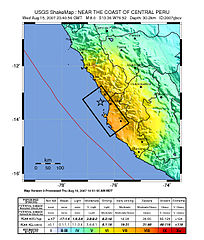
Image: Shake map of the magnitude 8.0 earthquake in Peru on August 15, 2007. Epicenter marked at star. Black box, placed by USGS, marks areas of Peru to be hardest hit.
Source: https://earthquake.usgs.gov/eqcenter/shakemap/global/shake/2007gbcv/
Licence
This image is in the public domain in the United States because it only contains materials that originally came from the United States Geological Survey, an agency of the United States Department of the Interior. For more information, see the official USGS copyright policy.
|

|
This map image could be re-created using vector graphics as an SVG file. This has several advantages; see Commons:Media for cleanup for more information. If an SVG form of this image is available, please upload it and afterwards replace this template with
{{vector version available|new image name}}.
It is recommended to name the SVG file “Peru Quake Aug 15-2007.svg”—then the template Vector version available (or Vva) does not need the new image name parameter. |


derivative works
Derivative works of this file: Peru Quake Aug 15-2007 cropped.jpg
Faila hronoloģija
Uzklikšķini uz datums/laiks kolonnā esošās saites, lai apskatītos, kā šis fails izskatījās tad.
| Datums/Laiks | Attēls | Izmēri | Dalībnieks | Komentārs | |
|---|---|---|---|---|---|
| tagadējais | 2007. gada 16. augusts, plkst. 23.25 | | 612 × 721 (155 KB) | DragonFire1024 | |
| 2007. gada 16. augusts, plkst. 08.15 |  | 612 × 721 (156 KB) | DragonFire1024 | ||
| 2007. gada 16. augusts, plkst. 03.56 |  | 612 × 721 (154 KB) | DragonFire1024 | '''Image:''' Shake map of the Peru earthquake on August 15, 2007. Epicenter marked at star. '''Source:''' http://earthquake.usgs.gov/eqcenter/shakemap/global/shake/2007gbcv/ |
Faila lietojums
Šo failu izmanto šajās 2 lapās:
Globālais faila lietojums
Šīs Vikipēdijas izmanto šo failu:
- Izmantojums ar.wikipedia.org
- Izmantojums azb.wikipedia.org
- Izmantojums bat-smg.wikipedia.org
- Izmantojums be-tarask.wikipedia.org
- Izmantojums be.wikipedia.org
- Izmantojums bn.wikipedia.org
- Izmantojums bs.wikipedia.org
- Izmantojums cs.wikipedia.org
- Izmantojums da.wikipedia.org
- Izmantojums de.wikipedia.org
- Izmantojums el.wikipedia.org
- Izmantojums en.wikipedia.org
- Izmantojums en.wikinews.org
- Izmantojums es.wikinews.org
- Izmantojums et.wikipedia.org
- Izmantojums fi.wikipedia.org
- Izmantojums fr.wikipedia.org
- Izmantojums hi.wikipedia.org
- Izmantojums id.wikipedia.org
- Izmantojums it.wikipedia.org
- Izmantojums it.wikinews.org
- Izmantojums ja.wikipedia.org
- Izmantojums ko.wikipedia.org
- Izmantojums mk.wikipedia.org
- Izmantojums ml.wikipedia.org
- Izmantojums ms.wikipedia.org
- Izmantojums my.wikipedia.org
- Izmantojums nah.wikipedia.org
- Izmantojums ne.wikipedia.org
- Izmantojums nn.wikipedia.org
- Izmantojums no.wikipedia.org
Skatīt šī faila pilno globālo izmantojumu.