Dalībnieks:Kode/Darbs 1
Izskats
| Datums | {{{datums}}} |
|---|---|
| Stiprums | {{{stiprums}}} |
| Skartās valstis | {{{skartās valstis}}} |
Dokumentācija[skatīt] [labot] [hronoloģija] [pārlādēt]
Usage
[labot šo sadaļu | labot pirmkodu]{{Zemestrīces infokaste
|nosaukums =
|attēls =
|attēla alt teksts =
|attēla virsraksts =
|karte =
|kartes alt teksts =
|attēla teksts =
|karte2 =
|kartes izmērs =
|virsraksts =
|datums = <!-- {{Dat|XXXX}} -->
|laiks =
|ilgums =
|stiprums = <!-- NNN balles pēc [[Rihtera skala]]s -->
|dziļums = <!-- {{convert|NNN|km|mi|0|abbr=on}} -->
|epicentrs = <!-- {{coord|XXXXX|display=inline,title}} -->
|tips =
|skartās valstis =
|postījumi =
|intensitāte =
|paātrinājums = <!-- NN''[[Paātrinājums|g]]'' -->
|cunami =
|nogruvumi =
|pēcgrūdieni =
|cietušie =
}}
Examples
[labot šo sadaļu | labot pirmkodu]
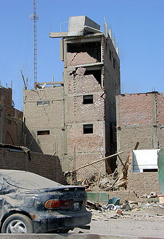
| |
| Effects of the earthquake on the Pan-American Highway between Ica and Lima | |
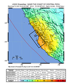
 | |
| Map of the Peru coastline, showing location and strength of quake. Star marks epicenter. | |
| Datums | Veidne:Start-date |
|---|---|
| Laiks | 23:40:57 UTC 18:40:57 PET |
| Ilgums | 3 minutes |
| Stiprums | 8.0 Mw |
| Dziļums | 39 km (24 mi) |
| Epicentrs | 13°21′14″S 76°30′32″W / 13.354°S 76.509°WKoordinātas: 13°21′14″S 76°30′32″W / 13.354°S 76.509°W |
| Skartās valstis | Peru |
| Cunami | flooded part of Lima's Costa Verde highway, and much of Pisco's shore |
| Cietušie | 519 confirmed dead 1,366 injured |
{{Lietotājs:Kode/Darbs_1
|virsraksts              = 2007 Peru earthquake
|attēls= 38 - Tremblement de terre - Août 2007.JPG
|attēla alt teksts          = Effects of the earthquake on the Pan-American Highway between Ica and Lima
|attēla virsrakst      = Effects of the earthquake on the Pan-American Highway between Ica and Lima
|karte= Peru Quake Aug 15-2007.jpg
|kartes alt teksts            = The quake's center was near the coast of central Peru; the closest settlements were Imperial and Chincha Alta. The damage zone went about 100 km inland and north, and about 200 km south.
|attēla teksts         = <small>Map of the Peru coastline, showing location and strength of quake. Star marks [[epicenter]].</small>
|datums               = {{Start-date|15 August 2007}}
|izcelsmes laiks= 23:40:57 [[UTC]]<br/> 18:40:57 [[Time in Peru|PET]]
|ilgums= 3 minutes
|stiprums          = 8.0 [[Moment magnitude scale|M<sub>w</sub>]]
|dziļums= {{convert|39|km|mi|0|abbr=on}}
|atrašanās vieta= {{coord|13.354|S|76.509|W|region:PE_type:event|display=inline,title}}
|skartās valstis = [[Peru]]
|cunami= flooded part of Lima's Costa Verde highway, and much of Pisco's shore
|cietušie= 519 confirmed dead<br /> 1,366 injured
}}
| Dokumentācija iekļauta no Dalībnieks:Kode/Darbs 1/doc (labot | hronoloģija) Vari eksperimentēt šīs veidnes smilšu kastes (izveidot | spoguļversija) un testu (izveidot) lapā Lūdzu, kategorijas pievieno dokumentācijas apakšlapā. Lapas apakšlapas. |
