
Attēls:Qinghai lake.jpg

Sākotnējais fails (640 × 640 pikseļi, faila izmērs: 138 KB, MIME tips: image/jpeg)
| Šis fails ir no Vikikrātuves. Tā apraksts no attēla lapas Vikikrātuvē ir parādīts zemāk. Vikikrātuve ir brīvi licencēta failu krātuve. Tu vari tai palīdzēt. |
Kopsavilkums
| Apraksts |
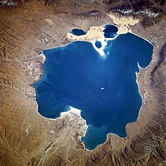
Deutsch: Qinghai-See, China - November 1994
English: Qinghai Lake, China - also, originally known as Koko Nor in Mongolian and Tso Ngonpo in Tibetan - November 1994
Español: Lago Qinghai, China - Noviembre 1994
中文:青海湖 |
|||||
| Datums | Taken on 1994. gada 8. novembris, 04:13:36 GMT | |||||
| Avots |
https://eol.jsc.nasa.gov/sseop/EFS/photoinfo.pl?PHOTO=STS066-118-23 https://eol.jsc.nasa.gov/SearchPhotos/photo.pl?mission=STS066&roll=118&frame=23 |
|||||
| Autors | NASA | |||||
| Atļauja: (Šī faila izmantošana citur) |
|
|||||
| NASA information |
|

| Camera location | | View this and other nearby images on: OpenStreetMap |
|---|
This image or video was catalogued by one of the centers of the United States National Aeronautics and Space Administration (NASA) under Photo ID: STS066-118-23. This tag does not indicate the copyright status of the attached work. A normal copyright tag is still required. See Commons:Licensing. Other languages:
|
Faila hronoloģija
Uzklikšķini uz datums/laiks kolonnā esošās saites, lai apskatītos, kā šis fails izskatījās tad.
| Datums/Laiks | Attēls | Izmēri | Dalībnieks | Komentārs | |
|---|---|---|---|---|---|
| tagadējais | 2005. gada 10. oktobris, plkst. 18.02 | | 640 × 640 (138 KB) | Immanuel Giel | Qinghai Lake, China - November 1994 '''Source''': from the English Wikipedia<br> image description [http://eol.jsc.nasa.gov/sseop/EFS/photoinfo.pl?PHOTO=STS066-118-23 here] en:Qinghai Lake {{PD-USGov-NASA}} |
Faila lietojums
Šo failu izmanto šajās 2 lapās:
Globālais faila lietojums
Šīs Vikipēdijas izmanto šo failu:
- Izmantojums ace.wikipedia.org
- Izmantojums ar.wikipedia.org
- Izmantojums ast.wikipedia.org
- Izmantojums az.wikipedia.org
- Izmantojums ba.wikipedia.org
- Izmantojums be.wikipedia.org
- Izmantojums bg.wikipedia.org
- Izmantojums bn.wikipedia.org
- Izmantojums bo.wikipedia.org
- Izmantojums br.wikipedia.org
- Izmantojums ca.wikipedia.org
- Izmantojums cdo.wikipedia.org
- Izmantojums ceb.wikipedia.org
- Izmantojums cs.wikipedia.org
- Izmantojums cv.wikipedia.org
- Izmantojums da.wikipedia.org
- Izmantojums de.wikipedia.org
- Izmantojums el.wikipedia.org
- Izmantojums en.wikipedia.org
- Izmantojums en.wikivoyage.org
- Izmantojums eo.wikipedia.org
Skatīt šī faila pilno globālo izmantojumu.