
Attēls:Abandoning the Arctic Exploration Ship Jeanette, by James Gale Tyler.jpg
Sākotnējais fails (852 × 581 pikseļi, faila izmērs: 148 KB, MIME tips: image/jpeg)
| Šis fails ir no Vikikrātuves. Tā apraksts no attēla lapas Vikikrātuvē ir parādīts zemāk. Vikikrātuve ir brīvi licencēta failu krātuve. Tu vari tai palīdzēt. |
Kopsavilkums
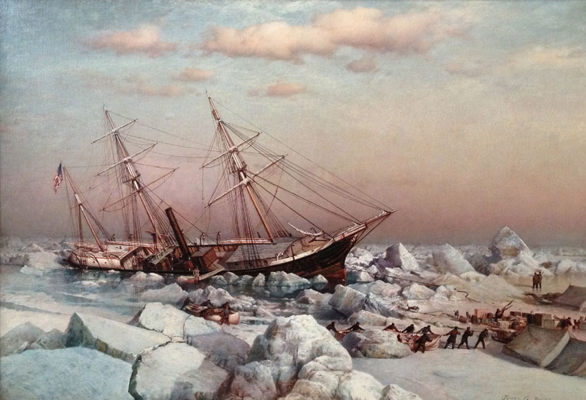
| James Gale Tyler: Abandoning the Arctic Exploration Ship Jeanette on June 12th 1891
|
||||||||||||||||||
|---|---|---|---|---|---|---|---|---|---|---|---|---|---|---|---|---|---|---|
| Izpildītājs |
|
 | ||||||||||||||||
| Nosaukums |
Abandoning the Arctic Exploration Ship Jeanette on June 12th 1891 |
|||||||||||||||||
| Object type | glezna | |||||||||||||||||
| Apraksts |
English: Abandoning the Arctic Exploration Ship Jeanette on June 12th 1891, by James Gale Tyler. A time-line of the expedition illustrates the enormity of the challenge the men faced. Publisher James Gordon Bennett, Jr. purchased the ship, previously the HMS Pandora, and allied with the U.S. Government to fund the expedition. The Jeanette left San Francisco on July 8, 1879 and was held fast in ice east of Wrangell Island by September. The ship drifted northwest in the ice for the rest of 1879, all of 1880 and landed at an island they named Henrietta Island, in honor of Bennett, on May 9, 1881. This was more than 600 miles from where they first became stuck. While trapped, the men led by Lieut. Commander George W. DeLong, Assistant Surgeon James Ambler, Lieut. Charles Chipp and Chief Engineer George W. Melville battled hunger and fierce atmospheric conditions, all while conducting their scientific assignments, hunting, and maintaining their ship. |
|||||||||||||||||
| Datums | 1883. gada | |||||||||||||||||
| Objekta vēsture | India House, New York | |||||||||||||||||
| Avots/Fotogrāfs | Vallejo Gallery | |||||||||||||||||
| Camera location | | View this and other nearby images on: OpenStreetMap |
|---|
Licence
|
This is a faithful photographic reproduction of a two-dimensional, public domain work of art. The work of art itself is in the public domain for the following reason:
The official position taken by the Wikimedia Foundation is that "faithful reproductions of two-dimensional public domain works of art are public domain".
This photographic reproduction is therefore also considered to be in the public domain in the United States. In other jurisdictions, re-use of this content may be restricted; see Reuse of PD-Art photographs for details. | ||||
Faila hronoloģija
Uzklikšķini uz datums/laiks kolonnā esošās saites, lai apskatītos, kā šis fails izskatījās tad.
| Datums/Laiks | Attēls | Izmēri | Dalībnieks | Komentārs | |
|---|---|---|---|---|---|
| tagadējais | 2019. gada 21. maijs, plkst. 21.26 | | 852 × 581 (148 KB) | Broichmore | Cropped 1 % horizontally, 3 % vertically using CropTool with precise mode. |
| 2019. gada 21. maijs, plkst. 21.24 |  | 864 × 599 (133 KB) | Broichmore | User created page with UploadWizard |
Faila lietojums
Šo failu izmanto šajā 1 lapā:
Globālais faila lietojums
Šīs Vikipēdijas izmanto šo failu:
- Izmantojums ca.wikipedia.org
- Izmantojums cs.wikipedia.org
- Izmantojums en.wikipedia.org
- Izmantojums ja.wikipedia.org
- Izmantojums ru.wikipedia.org
- Izmantojums www.wikidata.org