
Attēls:Brit IndianEmpireReligions3.jpg

Šī priekšskata izmērs: 741 × 599 pikseļi. Citi izmēri: 297 × 240 pikseļi | 593 × 480 pikseļi | 949 × 768 pikseļi | 1 266 × 1 024 pikseļi | 1 534 × 1 241 pikseļi.
Sākotnējais fails (1 534 × 1 241 pikseļi, faila izmērs: 2,33 MB, MIME tips: image/jpeg)
| Šis fails ir no Vikikrātuves. Tā apraksts no attēla lapas Vikikrātuvē ir parādīts zemāk. Vikikrātuve ir brīvi licencēta failu krātuve. Tu vari tai palīdzēt. |
Kopsavilkums
| Apraksts |
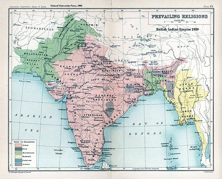
English: Map "Prevailing Religions of the British Indian Empire, 1909" Key:
|
| Datums | |
| Avots | The Imperial Gazetteer of India, Oxford University Press, 1909. Scanned from personal copy and annotated by me (Fowler&fowler«Talk» 04:16, 19 March 2007 (UTC)) |
| Autors |
English: John George Bartholomew |
| Citas versijas |
.jpg)


|
This old map image could be re-created using vector graphics as an SVG file. This has several advantages; see Commons:Media for cleanup for more information. If an SVG form of this image is available, please upload it and afterwards replace this template with
{{vector version available|new image name}}.
It is recommended to name the SVG file “Brit IndianEmpireReligions3.svg”—then the template Vector version available (or Vva) does not need the new image name parameter. |


Licence
|
The author died in 1920, so this work is in the public domain in its country of origin and other countries and areas where the copyright term is the author's life plus 100 years or fewer. Šis attēls ir publiskā lietošanā ASV teritorijā saskaņā ar ASV likumiem un normatīvajiem aktiem, jo ir pirmo reizi publicēts pirms 1929. gada 1. janvāra, vai ir publiskā lietošanā saskaņā ar citām juridiskām prasībām.. | |
| This file has been identified as being free of known restrictions under copyright law, including all related and neighboring rights. | |
Original upload log
The original description page was here. All following user names refer to en.wikipedia.
- 2007-03-19 04:16 Fowler&fowler 1650×1275×8 (338398 bytes) Map "Prevailing Religions of the British Indian Empire, 1909" from the Imperial Gazetteer of India, Oxford University Press, 1909. Scanned from personal copy and annotated by me (~~~~) {{PD-old-75}}
| Annotations | This image is annotated: View the annotations at Commons |
Faila hronoloģija
Uzklikšķini uz datums/laiks kolonnā esošās saites, lai apskatītos, kā šis fails izskatījās tad.
| Datums/Laiks | Attēls | Izmēri | Dalībnieks | Komentārs | |
|---|---|---|---|---|---|
| tagadējais | 2019. gada 18. janvāris, plkst. 05.39 | | 1 534 × 1 241 (2,33 MB) | Frank Klemm | Cropped, white balanced |
| 2011. gada 29. decembris, plkst. 16.27 |  | 1 504 × 1 232 (2,06 MB) | Maproom | Made colours less washed-out | |
| 2009. gada 11. februāris, plkst. 04.20 |  | 1 504 × 1 232 (311 KB) | AnonMoos | losslessly cropping margins | |
| 2007. gada 21. septembris, plkst. 06.06 |  | 1 650 × 1 275 (330 KB) | Shooke | {{Information |Description=Map "Prevailing Religions of the British Indian Empire, 1909" from the Imperial Gazetteer of India, Oxford University Press, 1909. Scanned from personal copy and annotated by me ([[:en:User:Fowler&fowler|<font color="#B8860B">F |
Faila lietojums
Šo failu izmanto šajā 1 lapā:
Globālais faila lietojums
Šīs Vikipēdijas izmanto šo failu:
- Izmantojums af.wikipedia.org
- Izmantojums ar.wikipedia.org
- Izmantojums ast.wikipedia.org
- Izmantojums az.wikipedia.org
- Izmantojums ba.wikipedia.org
- Izmantojums bg.wikipedia.org
- Izmantojums bn.wikipedia.org
- Izmantojums bn.wikiquote.org
- Izmantojums ca.wikipedia.org
- Izmantojums ckb.wikipedia.org
- Izmantojums cs.wikipedia.org
- Izmantojums de.wikipedia.org
- Izmantojums diq.wikipedia.org
- Izmantojums en.wikipedia.org
- History of India
- Kashmir
- Partition of India
- Gazetteer
- History of Hinduism
- Dominion of India
- British Raj
- User:Fowler&fowler
- Talk:History of Pakistan/History of the Pakistan region
- User:Fowler&fowler/Short History Indian Independence Movement
- User:Fowler&fowler/History of Pakistan
- History of the British Raj
- History of East Pakistan
- Talk:Jammu and Kashmir (state)/Archive 1
- User talk:RegentsPark/Archive 4
- User:Fowler&fowler/History of the Pakistan region
- Talk:British Raj/Archive 8
- User:Կիմա34/sandbox
- User:Falcaorib/India and Pakistan
- User:Fowler&fowler/British Raj
- Izmantojums es.wikipedia.org
- Izmantojums eu.wikipedia.org
- Izmantojums fa.wikipedia.org
- Izmantojums fr.wikipedia.org
Skatīt šī faila pilno globālo izmantojumu.