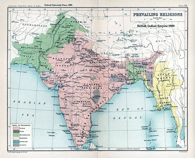
Attēls:Brit IndianEmpireReligions3.jpg
Izskats

Šī priekšskata izmērs: 741 × 599 pikseļi. Citi izmēri: 297 × 240 pikseļi | 593 × 480 pikseļi | 949 × 768 pikseļi | 1 266 × 1 024 pikseļi | 1 534 × 1 241 pikseļi.
Sākotnējais fails (1 534 × 1 241 pikseļi, faila izmērs: 2,33 MB, MIME tips: image/jpeg)
Faila hronoloģija
Uzklikšķini uz datums/laiks kolonnā esošās saites, lai apskatītos, kā šis fails izskatījās tad.
| Datums/Laiks | Attēls | Izmēri | Dalībnieks | Komentārs | |
|---|---|---|---|---|---|
| tagadējais | 2019. gada 18. janvāris, plkst. 04.39 |  | 1 534 × 1 241 (2,33 MB) | Frank Klemm | Cropped, white balanced |
| 2011. gada 29. decembris, plkst. 15.27 |  | 1 504 × 1 232 (2,06 MB) | Maproom | Made colours less washed-out | |
| 2009. gada 11. februāris, plkst. 03.20 |  | 1 504 × 1 232 (311 KB) | AnonMoos | losslessly cropping margins | |
| 2007. gada 21. septembris, plkst. 05.06 |  | 1 650 × 1 275 (330 KB) | Shooke | {{Information |Description=Map "Prevailing Religions of the British Indian Empire, 1909" from the Imperial Gazetteer of India, Oxford University Press, 1909. Scanned from personal copy and annotated by me ([[:en:User:Fowler&fowler|<font color="#B8860B">F |
Faila lietojums
Šo failu izmanto šajā 1 lapā:
Globālais faila lietojums
Šīs Vikipēdijas izmanto šo failu:
- Izmantojums af.wikipedia.org
- Izmantojums ar.wikipedia.org
- Izmantojums ast.wikipedia.org
- Izmantojums az.wikipedia.org
- Izmantojums ba.wikipedia.org
- Izmantojums bg.wikipedia.org
- Izmantojums bn.wikipedia.org
- Izmantojums bn.wikiquote.org
- Izmantojums ca.wikipedia.org
- Izmantojums ckb.wikipedia.org
- Izmantojums cs.wikipedia.org
- Izmantojums de.wikipedia.org
- Izmantojums diq.wikipedia.org
- Izmantojums en.wikipedia.org
- History of India
- Kashmir
- Partition of India
- Gazetteer
- History of Hinduism
- Dominion of India
- British Raj
- User:Fowler&fowler
- Talk:History of Pakistan/History of the Pakistan region
- User:Fowler&fowler/Short History Indian Independence Movement
- User:Fowler&fowler/History of Pakistan
- History of the British Raj
- History of East Pakistan
- Talk:Jammu and Kashmir (state)/Archive 1
- User talk:RegentsPark/Archive 4
- User:Fowler&fowler/History of the Pakistan region
- Talk:British Raj/Archive 8
- User:Կիմա34/sandbox
- User:Falcaorib/India and Pakistan
- User:Fowler&fowler/British Raj
- Izmantojums es.wikipedia.org
- Izmantojums eu.wikipedia.org
- Izmantojums fa.wikipedia.org
- Izmantojums fr.wikipedia.org
Skatīt šī faila pilno globālo izmantojumu.


